Leo-Cedarville geodata
Leo-Cedarville (Indiana) is a populated place; located in United States in America/Indiana/Indianapolis (GMT-4) time zone. With population of 3,842 people, there are 8405 cities with bigger population in this country. Compared to other cities in United States, 67.9% of cities are located further ↓South; 55.8% of cities are located further ←West and 61.4% of cities have lower elevation than Leo-Cedarville. Note1


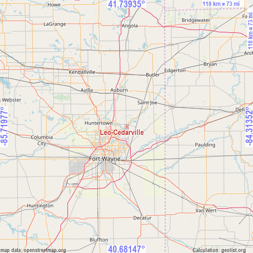
Leo-Cedarville GPS coordinates[2]
41° 12' 45.18" North, 85° 0' 59.904" West
| Map corner | latitude | longitude |
|---|---|---|
| Upper-left | 41.73935°, | -85.71977° |
| Center: | 41.21255°, | -85.01664° |
| Lower-right: | 40.68147°, | -84.31352° |
| Map W x H: | 117.6×117.6 km | = 73.1×73.1mi |
| max Lat: | 71.29058° ⇑32.1% North |
| Leo-Cedarville: | 41.21255° |
| min Lat: | ⇓67.9% South 19.06759° |
| min Long | Leo-Cedarville | max Long |
| -171.73463° | -85.01664° | -66.98998° |
| W 55.8%⇐ | ⇒44.2% E |
Elevation
Elevation of Leo-Cedarville is 246 m = 807 ft, and this is 48.8 m = 160 ft below average elevation for this country.
| Max E: |
3189 m = 10463 ft | 38.6% |
| Avg. | 294.8 m = 967 ft | |
| Leo-Cedarville | 246 m = 807 ft | |
Min E: |
-60 m = -197 ft | 61.4% |
See also: United States elevation on elevation.city.
Geographical zone
Leo-Cedarville is located in North temperate zone (between Tropic of Cancer and the Arctic Circle). Distance of this Northern Tropic circle is 1976.5 km =1228.1 mi to South.| Distance of | km | miles | from Leo-Cedarville |
|---|---|---|---|
| North Pole | 5424.7 | 3370.8 | to North |
| Arctic Circle | 2818.8 | 1751.5 | to North |
| Tropic Cancer | 1976.5 | 1228.1 | to South |
| Equator | 4582.4 | 2847.4 | to South |


Nearby cities:
15 places around Leo-Cedarville: (largest is in red/bold)
• Antwerp
23.4 km =14.5 mi,  98°
98°
• Auburn
17.5 km =10.9 mi,  348°
348°
• Avilla
25.2 km =15.7 mi,  312°
312°
• Butler
27 km =16.8 mi,  26°
26°
• Churubusco
25.4 km =15.8 mi,  274°
274°
• Fort Wayne
13.1 km =8.1 mi,  225°
225°
• Garrett
18.2 km =11.3 mi,  326°
326°
• Grabill
4.2 km =2.6 mi,  92°
92°
• Harlan
8.3 km =5.2 mi, 102°
• Hicksville
23.1 km =14.4 mi,  67°
67°
• Huntertown
13.2 km =8.2 mi,  277°
277°
• New Haven
15.8 km =9.8 mi,  179°
179°
• Payne
28.5 km =17.7 mi,  121°
121°
• Waterloo
24.4 km =15.2 mi,  359°
359°
• Woodburn
16.8 km =10.4 mi,  125°
125°
Sources, notices
• [Note1] Compared only with cities in United States existing in our database
• [Src1] Map data: © OpenStreetMap contributors (CC-BY-SA)
• [Src2] Other city data from geonames.org with taken over terms of usage.
• [Src3] Geographical zone / Annual Mean Temperature by Robert A. Rohde @ Wikipedia
