Kendallville geodata
Kendallville (Indiana) is a populated place; located in United States in America/Indiana/Indianapolis (GMT-4) time zone. With population of 9,927 people, there are 4482 cities with bigger population in this country. Compared to other cities in United States, 70.2% of cities are located further ↓South; 55.2% of cities are located further ←West and 73.1% of cities have lower elevation than Kendallville. Note1


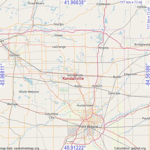
Kendallville GPS coordinates[2]
41° 26' 29.184" North, 85° 15' 53.928" West
| Map corner | latitude | longitude |
|---|---|---|
| Upper-left | 41.96638°, | -85.96811° |
| Center: | 41.44144°, | -85.26498° |
| Lower-right: | 40.91222°, | -84.56186° |
| Map W x H: | 117.2×117.2 km | = 72.8×72.8mi |
| max Lat: | 71.29058° ⇑29.8% North |
| Kendallville: | 41.44144° |
| min Lat: | ⇓70.2% South 19.06759° |
| min Long | Kendallville | max Long |
| -171.73463° | -85.26498° | -66.98998° |
| W 55.2%⇐ | ⇒44.8% E |
Elevation
Elevation of Kendallville is 302 m = 991 ft, and this is 7.2 m = 24 ft above average elevation for this country.
| Max E: |
3189 m = 10463 ft | 26.9% |
| Kendallville | 302 m 991 ft | |
| Avg. | 294.8 m = 967 ft | |
Min E: |
-60 m = -197 ft | 73.1% |
See also: United States elevation on elevation.city.
Geographical zone
Kendallville is located in North temperate zone (between Tropic of Cancer and the Arctic Circle). Distance of this Northern Tropic circle is 2001.9 km =1243.9 mi to South.| Distance of | km | miles | from Kendallville |
|---|---|---|---|
| North Pole | 5399.2 | 3354.9 | to North |
| Arctic Circle | 2793.3 | 1735.7 | to North |
| Tropic Cancer | 2001.9 | 1243.9 | to South |
| Equator | 4607.9 | 2863.2 | to South |


Nearby cities:
15 places around Kendallville: (largest is in red/bold)
• Albion
14.2 km =8.8 mi,  249°
249°
• Ashley
19 km =11.8 mi,  60°
60°
• Auburn
19.1 km =11.9 mi,  115°
115°
• Avilla
8.7 km =5.4 mi,  165°
165°
• Churubusco
23.9 km =14.9 mi,  190°
190°
• Garrett
14.9 km =9.3 mi,  133°
133°
• Hudson
18.4 km =11.4 mi, 56°
• Huntertown
24.9 km =15.5 mi,  161°
161°
• Lagrange
25.6 km =15.9 mi,  330°
330°
• Ligonier
27 km =16.8 mi,  275°
275°
• Rome City
11.1 km =6.9 mi,  303°
303°
• Topeka
25.3 km =15.7 mi, 295°
• Tri-Lakes
26.3 km =16.3 mi,  214°
214°
• Waterloo
20.5 km =12.7 mi,  92°
92°
• Wolcottville
12.6 km =7.8 mi,  317°
317°
Sources, notices
• [Note1] Compared only with cities in United States existing in our database
• [Src1] Map data: © OpenStreetMap contributors (CC-BY-SA)
• [Src2] Other city data from geonames.org with taken over terms of usage.
• [Src3] Geographical zone / Annual Mean Temperature by Robert A. Rohde @ Wikipedia
