Churubusco geodata
Churubusco (Indiana) is a populated place; located in United States in America/Indiana/Indianapolis (GMT-4) time zone. With population of 1,795 people, there are 12555 cities with bigger population in this country. Compared to other cities in United States, 68.1% of cities are located further ↓South; 55% of cities are located further ←West and 67.4% of cities have lower elevation than Churubusco. Note1


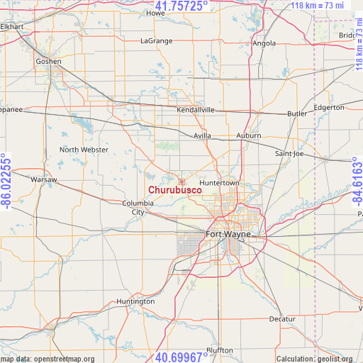
Churubusco GPS coordinates[2]
41° 13' 50.16" North, 85° 19' 9.912" West
| Map corner | latitude | longitude |
|---|---|---|
| Upper-left | 41.75725°, | -86.02255° |
| Center: | 41.2306°, | -85.31942° |
| Lower-right: | 40.69967°, | -84.6163° |
| Map W x H: | 117.6×117.6 km | = 73.1×73.1mi |
| max Lat: | 71.29058° ⇑31.9% North |
| Churubusco: | 41.2306° |
| min Lat: | ⇓68.1% South 19.06759° |
| min Long | Churubusco | max Long |
| -171.73463° | -85.31942° | -66.98998° |
| W 55%⇐ | ⇒45% E |
Elevation
Elevation of Churubusco is 273 m = 896 ft, and this is 21.8 m = 72 ft below average elevation for this country.
| Max E: |
3189 m = 10463 ft | 32.6% |
| Avg. | 294.8 m = 967 ft | |
| Churubusco | 273 m = 896 ft | |
Min E: |
-60 m = -197 ft | 67.4% |
See also: United States elevation on elevation.city.
Geographical zone
Churubusco is located in North temperate zone (between Tropic of Cancer and the Arctic Circle). Distance of this Northern Tropic circle is 1978.5 km =1229.4 mi to South.| Distance of | km | miles | from Churubusco |
|---|---|---|---|
| North Pole | 5422.6 | 3369.4 | to North |
| Arctic Circle | 2816.8 | 1750.3 | to North |
| Tropic Cancer | 1978.5 | 1229.4 | to South |
| Equator | 4584.4 | 2848.6 | to South |


Nearby cities:
15 places around Churubusco: (largest is in red/bold)
• Albion
20.3 km =12.6 mi,  334°
334°
• Auburn
26.5 km =16.5 mi,  55°
55°
• Avilla
16.5 km =10.3 mi,  24°
24°
• Columbia City
16.3 km =10.1 mi,  240°
240°
• Fort Wayne
19.4 km =12.1 mi,  124°
124°
• Garrett
20.3 km =12.6 mi,  49°
49°
• Grabill
29.6 km =18.4 mi,  94°
94°
• Huntertown
12.3 km =7.6 mi, 91°
• Kendallville
23.9 km =14.9 mi,  10°
10°
• Leo-Cedarville
25.4 km =15.8 mi, 94°
• New Haven
31.1 km =19.3 mi, 124°
• Roanoke
30.1 km =18.7 mi,  188°
188°
• Rome City
29.9 km =18.6 mi,  350°
350°
• South Whitley
30.5 km =19 mi, 237°
• Tri-Lakes
10.4 km =6.5 mi,  279°
279°
Sources, notices
• [Note1] Compared only with cities in United States existing in our database
• [Src1] Map data: © OpenStreetMap contributors (CC-BY-SA)
• [Src2] Other city data from geonames.org with taken over terms of usage.
• [Src3] Geographical zone / Annual Mean Temperature by Robert A. Rohde @ Wikipedia
