Gary geodata
Gary (Indiana) is a populated place; located in United States in America/Chicago (GMT-5) time zone. With population of 77,156 people, there are 517 cities with bigger population in this country. Compared to other cities in United States, 71.8% of cities are located further ↓South; 50.5% of cities are located further →East and 53.6% of cities have higher elevation than Gary. Note1


Gary GPS coordinates[2]
41° 35' 36.132" North, 87° 20' 47.148" West
| Map corner | latitude | longitude |
|---|---|---|
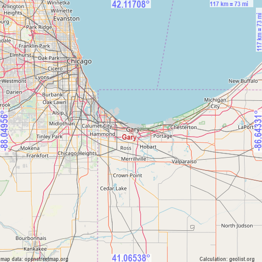
| Upper-left | 42.11708°, | -88.04956° |
| Center: | 41.59337°, | -87.34643° |
| Lower-right: | 41.06538°, | -86.64331° |
| Map W x H: | 116.9×116.9 km | = 72.6×72.6mi |
| max Lat: | 71.29058° ⇑28.2% North |
| Gary: | 41.59337° |
| min Lat: | ⇓71.8% South 19.06759° |
| min Long | Gary | max Long |
| -171.73463° | -87.34643° | -66.98998° |
| W 49.5%⇐ | ⇒50.5% E |
Elevation
Elevation of Gary is 185 m = 607 ft, and this is 109.8 m = 360 ft below average elevation for this country.
| Max E: |
3189 m = 10463 ft | 53.6% |
| Avg. | 294.8 m = 967 ft | |
| Gary | 185 m = 607 ft | |
Min E: |
-60 m = -197 ft | 46.4% |
See also: Gary elevation on elevation.city.
Geographical zone
Gary is located in North temperate zone (between Tropic of Cancer and the Arctic Circle). Distance of this Northern Tropic circle is 2018.8 km =1254.4 mi to South.| Distance of | km | miles | from Gary |
|---|---|---|---|
| North Pole | 5382.3 | 3344.4 | to North |
| Arctic Circle | 2776.4 | 1725.2 | to North |
| Tropic Cancer | 2018.8 | 1254.4 | to South |
| Equator | 4624.7 | 2873.7 | to South |


Nearby cities:
15 places around Gary: (largest is in red/bold)
• Calumet City
15.4 km =9.6 mi,  279°
279°
• East Chicago
10.3 km =6.4 mi,  299°
299°
• Griffith
9.7 km =6 mi,  221°
221°
• Hammond
12.8 km =8 mi,  265°
265°
• Highland
9.8 km =6.1 mi,  243°
243°
• Hobart
10.2 km =6.3 mi,  131°
131°
• Lake Station
9.2 km =5.7 mi,  102°
102°
• Lansing
16.3 km =10.1 mi,  258°
258°
• Merrillville
12.3 km =7.6 mi,  174°
174°
• Munster
14.2 km =8.8 mi, 256°
• New Chicago
7.1 km =4.4 mi,  123°
123°
• Ogden Dunes
13.3 km =8.3 mi,  75°
75°
• Portage
14.3 km =8.9 mi, 97°
• Schererville
15.6 km =9.7 mi, 215°
• Whiting
15.6 km =9.7 mi,  307°
307°
Sources, notices
• [Note1] Compared only with cities in United States existing in our database
• [Src1] Map data: © OpenStreetMap contributors (CC-BY-SA)
• [Src2] Other city data from geonames.org with taken over terms of usage.
• [Src3] Geographical zone / Annual Mean Temperature by Robert A. Rohde @ Wikipedia
