Boswell geodata
Boswell (Indiana) is a populated place; located in United States in America/Indiana/Indianapolis (GMT-4) time zone. With population of 762 people, there are 18109 cities with bigger population in this country. Compared to other cities in United States, 59.1% of cities are located further ↓South; 50.5% of cities are located further →East and 57.9% of cities have lower elevation than Boswell. Note1


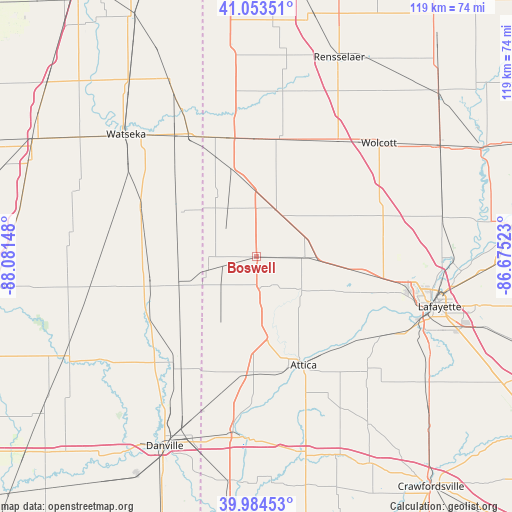
Boswell GPS coordinates[2]
40° 31' 16.14" North, 87° 22' 42.06" West
| Map corner | latitude | longitude |
|---|---|---|
| Upper-left | 41.05351°, | -88.08148° |
| Center: | 40.52115°, | -87.37835° |
| Lower-right: | 39.98453°, | -86.67523° |
| Map W x H: | 118.9×118.9 km | = 73.9×73.9mi |
| max Lat: | 71.29058° ⇑40.9% North |
| Boswell: | 40.52115° |
| min Lat: | ⇓59.1% South 19.06759° |
| min Long | Boswell | max Long |
| -171.73463° | -87.37835° | -66.98998° |
| W 49.5%⇐ | ⇒50.5% E |
Elevation
Elevation of Boswell is 230 m = 755 ft, and this is 64.8 m = 213 ft below average elevation for this country.
| Max E: |
3189 m = 10463 ft | 42.1% |
| Avg. | 294.8 m = 967 ft | |
| Boswell | 230 m = 755 ft | |
Min E: |
-60 m = -197 ft | 57.9% |
See also: United States elevation on elevation.city.
Geographical zone
Boswell is located in North temperate zone (between Tropic of Cancer and the Arctic Circle). Distance of this Northern Tropic circle is 1899.6 km =1180.4 mi to South.| Distance of | km | miles | from Boswell |
|---|---|---|---|
| North Pole | 5501.5 | 3418.5 | to North |
| Arctic Circle | 2895.6 | 1799.2 | to North |
| Tropic Cancer | 1899.6 | 1180.4 | to South |
| Equator | 4505.5 | 2799.6 | to South |


Nearby cities:
15 places around Boswell: (largest is in red/bold)
• Attica
27.5 km =17.1 mi,  156°
156°
• Bismarck
34.6 km =21.5 mi,  214°
214°
• Fowler
11.7 km =7.3 mi,  24°
24°
• Goodland
27.9 km =17.3 mi,  14°
14°
• Hoopeston
25.2 km =15.7 mi,  256°
256°
• Kentland
28.3 km =17.6 mi,  348°
348°
• Milford
29.4 km =18.3 mi,  293°
293°
• Otterbein
24.1 km =15 mi,  98°
98°
• Oxford
11 km =6.8 mi,  90°
90°
• Remington
32.8 km =20.4 mi,  35°
35°
• Rossville
29.2 km =18.1 mi,  237°
237°
• Sheldon
31.7 km =19.7 mi,  330°
330°
• West Lebanon
27.9 km =17.3 mi,  181°
181°
• Westpoint
34.5 km =21.4 mi,  124°
124°
• Williamsport
26.9 km =16.7 mi, 164°
Sources, notices
• [Note1] Compared only with cities in United States existing in our database
• [Src1] Map data: © OpenStreetMap contributors (CC-BY-SA)
• [Src2] Other city data from geonames.org with taken over terms of usage.
• [Src3] Geographical zone / Annual Mean Temperature by Robert A. Rohde @ Wikipedia
