Kingsford Heights geodata
Kingsford Heights (Indiana) is a populated place; located in United States in America/Chicago (GMT-5) time zone. With population of 1,421 people, there are 14009 cities with bigger population in this country. Compared to other cities in United States, 70.6% of cities are located further ↓South; 51.1% of cities are located further ←West and 55.8% of cities have lower elevation than Kingsford Heights. Note1


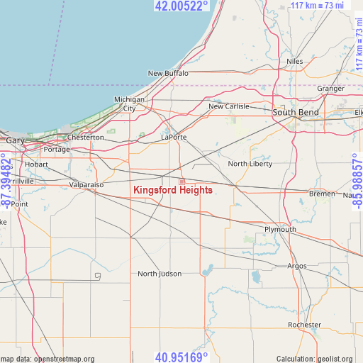
Kingsford Heights GPS coordinates[2]
41° 28' 50.16" North, 86° 41' 30.084" West
| Map corner | latitude | longitude |
|---|---|---|
| Upper-left | 42.00522°, | -87.39482° |
| Center: | 41.4806°, | -86.69169° |
| Lower-right: | 40.95169°, | -85.98857° |
| Map W x H: | 117.1×117.1 km | = 72.8×72.8mi |
| max Lat: | 71.29058° ⇑29.4% North |
| Kingsford Heights: | 41.4806° |
| min Lat: | ⇓70.6% South 19.06759° |
| min Long | Kingsford Heigh | max Long |
| -171.73463° | -86.69169° | -66.98998° |
| W 51.1%⇐ | ⇒48.9% E |
Elevation
Elevation of Kingsford Heights is 222 m = 728 ft, and this is 72.8 m = 239 ft below average elevation for this country.
| Max E: |
3189 m = 10463 ft | 44.2% |
| Avg. | 294.8 m = 967 ft | |
| Kingsford Heights | 222 m = 728 ft | |
Min E: |
-60 m = -197 ft | 55.8% |
See also: United States elevation on elevation.city.
Geographical zone
Kingsford Heights is located in North temperate zone (between Tropic of Cancer and the Arctic Circle). Distance of this Northern Tropic circle is 2006.3 km =1246.7 mi to South.| Distance of | km | miles | from Kingsford Heights |
|---|---|---|---|
| North Pole | 5394.9 | 3352.2 | to North |
| Arctic Circle | 2789 | 1733 | to North |
| Tropic Cancer | 2006.3 | 1246.7 | to South |
| Equator | 4612.2 | 2865.9 | to South |


Nearby cities:
15 places around Kingsford Heights: (largest is in red/bold)
• Fish Lake
15.1 km =9.4 mi,  50°
50°
• Hamlet
11.8 km =7.3 mi, 50°
• Hudson Lake
28.7 km =17.8 mi,  27°
27°
• Knox
21.3 km =13.2 mi,  164°
164°
• Koontz Lake
18.5 km =11.5 mi,  112°
112°
• La Crosse
24.6 km =15.3 mi,  222°
222°
• La Porte
14.3 km =8.9 mi,  352°
352°
• LaPorte
14.7 km =9.1 mi, 349°
• New Carlisle
28.7 km =17.8 mi, 31°
• North Liberty
22.8 km =14.2 mi,  74°
74°
• Rolling Prairie
22.1 km =13.7 mi,  16°
16°
• Trail Creek
27.9 km =17.3 mi,  330°
330°
• Walkerton
17.4 km =10.8 mi,  95°
95°
• Wanatah
18.1 km =11.2 mi,  252°
252°
• Westville
18.7 km =11.6 mi,  291°
291°
Sources, notices
• [Note1] Compared only with cities in United States existing in our database
• [Src1] Map data: © OpenStreetMap contributors (CC-BY-SA)
• [Src2] Other city data from geonames.org with taken over terms of usage.
• [Src3] Geographical zone / Annual Mean Temperature by Robert A. Rohde @ Wikipedia
