Hamlet geodata
Hamlet (Indiana) is a populated place; located in United States in America/Chicago (GMT-5) time zone. With population of 800 people, there are 17812 cities with bigger population in this country. Compared to other cities in United States, 71.4% of cities are located further ↓South; 51.3% of cities are located further ←West and 53.7% of cities have lower elevation than Hamlet. Note1


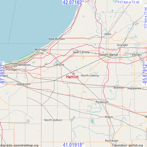
Hamlet GPS coordinates[2]
41° 32' 51.144" North, 86° 34' 56.064" West
| Map corner | latitude | longitude |
|---|---|---|
| Upper-left | 42.07162°, | -87.28537° |
| Center: | 41.54754°, | -86.58224° |
| Lower-right: | 41.01918°, | -85.87912° |
| Map W x H: | 117×117 km | = 72.7×72.7mi |
| max Lat: | 71.29058° ⇑28.6% North |
| Hamlet: | 41.54754° |
| min Lat: | ⇓71.4% South 19.06759° |
| min Long | Hamlet | max Long |
| -171.73463° | -86.58224° | -66.98998° |
| W 51.3%⇐ | ⇒48.7% E |
Elevation
Elevation of Hamlet is 213 m = 699 ft, and this is 81.8 m = 268 ft below average elevation for this country.
| Max E: |
3189 m = 10463 ft | 46.3% |
| Avg. | 294.8 m = 967 ft | |
| Hamlet | 213 m = 699 ft | |
Min E: |
-60 m = -197 ft | 53.7% |
See also: United States elevation on elevation.city.
Geographical zone
Hamlet is located in North temperate zone (between Tropic of Cancer and the Arctic Circle). Distance of this Northern Tropic circle is 2013.7 km =1251.3 mi to South.| Distance of | km | miles | from Hamlet |
|---|---|---|---|
| North Pole | 5387.4 | 3347.6 | to North |
| Arctic Circle | 2781.5 | 1728.3 | to North |
| Tropic Cancer | 2013.7 | 1251.3 | to South |
| Equator | 4619.7 | 2870.5 | to South |


Nearby cities:
15 places around Hamlet: (largest is in red/bold)
• Fish Lake
3.3 km =2.1 mi,  49°
49°
• Hudson Lake
18.5 km =11.5 mi,  12°
12°
• Kingsford Heights
11.8 km =7.3 mi,  230°
230°
• Knox
28.2 km =17.5 mi,  187°
187°
• Koontz Lake
16.5 km =10.3 mi,  150°
150°
• La Paz
24.8 km =15.4 mi,  113°
113°
• La Porte
12.8 km =8 mi,  301°
301°
• LaPorte
13.6 km =8.5 mi, 301°
• Lakeville
25.8 km =16 mi,  95°
95°
• New Carlisle
18 km =11.2 mi,  19°
19°
• North Liberty
13 km =8.1 mi, 96°
• Rolling Prairie
14 km =8.7 mi,  348°
348°
• Three Oaks
28 km =17.4 mi,  355°
355°
• Walkerton
12.2 km =7.6 mi,  137°
137°
• Westville
26.5 km =16.5 mi,  268°
268°
Sources, notices
• [Note1] Compared only with cities in United States existing in our database
• [Src1] Map data: © OpenStreetMap contributors (CC-BY-SA)
• [Src2] Other city data from geonames.org with taken over terms of usage.
• [Src3] Geographical zone / Annual Mean Temperature by Robert A. Rohde @ Wikipedia
