Wanatah geodata
Wanatah (Indiana) is a populated place; located in United States in America/Chicago (GMT-5) time zone. With population of 1,024 people, there are 16121 cities with bigger population in this country. Compared to other cities in United States, 70.1% of cities are located further ↓South; 50.5% of cities are located further ←West and 56.9% of cities have lower elevation than Wanatah. Note1


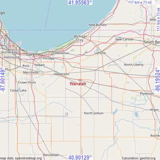
Wanatah GPS coordinates[2]
41° 25' 50.16" North, 86° 53' 54.096" West
| Map corner | latitude | longitude |
|---|---|---|
| Upper-left | 41.95563°, | -87.60149° |
| Center: | 41.4306°, | -86.89836° |
| Lower-right: | 40.90129°, | -86.19524° |
| Map W x H: | 117.2×117.2 km | = 72.8×72.8mi |
| max Lat: | 71.29058° ⇑29.9% North |
| Wanatah: | 41.4306° |
| min Lat: | ⇓70.1% South 19.06759° |
| min Long | Wanatah | max Long |
| -171.73463° | -86.89836° | -66.98998° |
| W 50.5%⇐ | ⇒49.5% E |
Elevation
Elevation of Wanatah is 226 m = 741 ft, and this is 68.8 m = 226 ft below average elevation for this country.
| Max E: |
3189 m = 10463 ft | 43.1% |
| Avg. | 294.8 m = 967 ft | |
| Wanatah | 226 m = 741 ft | |
Min E: |
-60 m = -197 ft | 56.9% |
See also: United States elevation on elevation.city.
Geographical zone
Wanatah is located in North temperate zone (between Tropic of Cancer and the Arctic Circle). Distance of this Northern Tropic circle is 2000.7 km =1243.2 mi to South.| Distance of | km | miles | from Wanatah |
|---|---|---|---|
| North Pole | 5400.4 | 3355.7 | to North |
| Arctic Circle | 2794.5 | 1736.4 | to North |
| Tropic Cancer | 2000.7 | 1243.2 | to South |
| Equator | 4606.7 | 2862.5 | to South |


Nearby cities:
15 places around Wanatah: (largest is in red/bold)
• Aberdeen
17.8 km =11.1 mi,  272°
272°
• Chesterton
24.3 km =15.1 mi,  325°
325°
• Kingsford Heights
18.1 km =11.2 mi,  72°
72°
• Knox
27.3 km =17 mi,  123°
123°
• Kouts
16.5 km =10.3 mi,  220°
220°
• La Crosse
12.6 km =7.8 mi,  177°
177°
• La Porte
25 km =15.5 mi,  37°
37°
• LaPorte
24.8 km =15.4 mi, 36°
• Lakes of the Four Seasons
26.3 km =16.3 mi, 265°
• North Judson
26.1 km =16.2 mi,  156°
156°
• Porter
25.2 km =15.7 mi,  324°
324°
• Shorewood Forest
20.8 km =12.9 mi,  279°
279°
• South Haven
23.4 km =14.5 mi,  301°
301°
• Valparaiso
14.4 km =8.9 mi,  289°
289°
• Westville
12.3 km =7.6 mi,  359°
359°
Sources, notices
• [Note1] Compared only with cities in United States existing in our database
• [Src1] Map data: © OpenStreetMap contributors (CC-BY-SA)
• [Src2] Other city data from geonames.org with taken over terms of usage.
• [Src3] Geographical zone / Annual Mean Temperature by Robert A. Rohde @ Wikipedia
