Lagrange geodata
Lagrange (Indiana) is a seat of a second-order administrative division; located in United States in America/Indiana/Indianapolis (GMT-4) time zone. With population of 2,715 people, there are 10145 cities with bigger population in this country. Compared to other cities in United States, 72.3% of cities are located further ↓South; 54.8% of cities are located further ←West and 69.9% of cities have lower elevation than Lagrange. Note1
Administrative division(s):
- Level 1: Indiana
- Level 2: LaGrange County
- Level 3: Township of Bloomfield


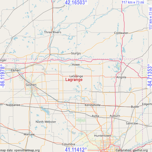
Lagrange GPS coordinates[2]
41° 38' 30.192" North, 85° 24' 59.94" West
| Map corner | latitude | longitude |
|---|---|---|
| Upper-left | 42.16503°, | -86.11978° |
| Center: | 41.64172°, | -85.41665° |
| Lower-right: | 41.11412°, | -84.71353° |
| Map W x H: | 116.9×116.8 km | = 72.6×72.6mi |
| max Lat: | 71.29058° ⇑27.7% North |
| Lagrange: | 41.64172° |
| min Lat: | ⇓72.3% South 19.06759° |
| min Long | Lagrange | max Long |
| -171.73463° | -85.41665° | -66.98998° |
| W 54.8%⇐ | ⇒45.2% E |
Elevation
Elevation of Lagrange is 285 m = 935 ft, and this is 9.8 m = 32 ft below average elevation for this country.
| Max E: |
3189 m = 10463 ft | 30.1% |
| Avg. | 294.8 m = 967 ft | |
| Lagrange | 285 m = 935 ft | |
Min E: |
-60 m = -197 ft | 69.9% |
See also: United States elevation on elevation.city.
Geographical zone
Lagrange is located in North temperate zone (between Tropic of Cancer and the Arctic Circle). Distance of this Northern Tropic circle is 2024.2 km =1257.8 mi to South.| Distance of | km | miles | from Lagrange |
|---|---|---|---|
| North Pole | 5376.9 | 3341 | to North |
| Arctic Circle | 2771 | 1721.8 | to North |
| Tropic Cancer | 2024.2 | 1257.8 | to South |
| Equator | 4630.1 | 2877 | to South |


Nearby cities:
15 places around Lagrange: (largest is in red/bold)
• Albion
27.4 km =17 mi,  181°
181°
• Burr Oak
24.3 km =15.1 mi,  19°
19°
• Constantine
30.5 km =19 mi,  316°
316°
• Howe
8.9 km =5.5 mi,  357°
357°
• Hudson
30.4 km =18.9 mi,  113°
113°
• Kendallville
25.6 km =15.9 mi,  150°
150°
• Ligonier
24.2 km =15 mi,  216°
216°
• Middlebury
24.3 km =15.1 mi,  278°
278°
• Millersburg
26.3 km =16.3 mi,  241°
241°
• Rome City
16.5 km =10.3 mi,  168°
168°
• Shipshewana
14 km =8.7 mi, 284°
• Sturgis
17.5 km =10.9 mi, 359°
• Topeka
15.3 km =9.5 mi, 221°
• White Pigeon
25.6 km =15.9 mi,  312°
312°
• Wolcottville
13.5 km =8.4 mi,  162°
162°
Sources, notices
• [Note1] Compared only with cities in United States existing in our database
• [Src1] Map data: © OpenStreetMap contributors (CC-BY-SA)
• [Src2] Other city data from geonames.org with taken over terms of usage.
• [Src3] Geographical zone / Annual Mean Temperature by Robert A. Rohde @ Wikipedia
