Constantine geodata
Constantine (Michigan) is a populated place; located in United States in America/Detroit (GMT-4) time zone. With population of 2,064 people, there are 11740 cities with bigger population in this country. Compared to other cities in United States, 74.3% of cities are located further ↓South; 53.9% of cities are located further ←West and 60.5% of cities have lower elevation than Constantine. Note1
Administrative division(s):
- Level 1: Michigan
- Level 2: Saint Joseph County
- Level 3: Township of Constantine


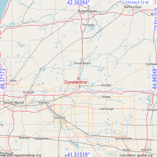
Constantine GPS coordinates[2]
41° 50' 28.176" North, 85° 40' 6.96" West
| Map corner | latitude | longitude |
|---|---|---|
| Upper-left | 42.36284°, | -86.37173° |
| Center: | 41.84116°, | -85.6686° |
| Lower-right: | 41.31519°, | -84.96548° |
| Map W x H: | 116.5×116.5 km | = 72.4×72.4mi |
| max Lat: | 71.29058° ⇑25.7% North |
| Constantine: | 41.84116° |
| min Lat: | ⇓74.3% South 19.06759° |
| min Long | Constantine | max Long |
| -171.73463° | -85.6686° | -66.98998° |
| W 53.9%⇐ | ⇒46.1% E |
Elevation
Elevation of Constantine is 242 m = 794 ft, and this is 52.8 m = 173 ft below average elevation for this country.
| Max E: |
3189 m = 10463 ft | 39.5% |
| Avg. | 294.8 m = 967 ft | |
| Constantine | 242 m = 794 ft | |
Min E: |
-60 m = -197 ft | 60.5% |
See also: United States elevation on elevation.city.
Geographical zone
Constantine is located in North temperate zone (between Tropic of Cancer and the Arctic Circle). Distance of this Northern Tropic circle is 2046.4 km =1271.6 mi to South.| Distance of | km | miles | from Constantine |
|---|---|---|---|
| North Pole | 5354.8 | 3327.3 | to North |
| Arctic Circle | 2748.9 | 1708.1 | to North |
| Tropic Cancer | 2046.4 | 1271.6 | to South |
| Equator | 4652.3 | 2890.8 | to South |


Nearby cities:
15 places around Constantine: (largest is in red/bold)
• Bristol
18.2 km =11.3 mi,  222°
222°
• Burr Oak
29 km =18 mi,  88°
88°
• Cassopolis
29.3 km =18.2 mi,  285°
285°
• Centreville
14.8 km =9.2 mi,  51°
51°
• Howe
24.5 km =15.2 mi,  122°
122°
• Lagrange
30.5 km =19 mi,  136°
136°
• Marcellus
23.9 km =14.9 mi,  329°
329°
• Mendon
25.8 km =16 mi,  44°
44°
• Middlebury
18.7 km =11.6 mi,  189°
189°
• Schoolcraft
30.5 km =19 mi,  4°
4°
• Shipshewana
20.1 km =12.5 mi,  158°
158°
• Simonton Lake
27.2 km =16.9 mi,  249°
249°
• Sturgis
21.2 km =13.2 mi,  102°
102°
• Three Rivers
11.8 km =7.3 mi,  14°
14°
• White Pigeon
5.2 km =3.2 mi, 156°
Sources, notices
• [Note1] Compared only with cities in United States existing in our database
• [Src1] Map data: © OpenStreetMap contributors (CC-BY-SA)
• [Src2] Other city data from geonames.org with taken over terms of usage.
• [Src3] Geographical zone / Annual Mean Temperature by Robert A. Rohde @ Wikipedia
