Burr Oak geodata
Burr Oak (Michigan) is a populated place; located in United States in America/Detroit (GMT-4) time zone. With population of 819 people, there are 17635 cities with bigger population in this country. Compared to other cities in United States, 74.3% of cities are located further ↓South; 55% of cities are located further ←West and 67.6% of cities have lower elevation than Burr Oak. Note1
Administrative division(s):
- Level 1: Michigan
- Level 2: Saint Joseph County
- Level 3: Township of Burr Oak


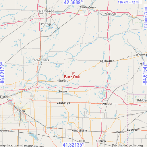
Burr Oak GPS coordinates[2]
41° 50' 50.172" North, 85° 19' 6.924" West
| Map corner | latitude | longitude |
|---|---|---|
| Upper-left | 42.3689°, | -86.02172° |
| Center: | 41.84727°, | -85.31859° |
| Lower-right: | 41.32135°, | -84.61547° |
| Map W x H: | 116.5×116.5 km | = 72.4×72.4mi |
| max Lat: | 71.29058° ⇑25.7% North |
| Burr Oak: | 41.84727° |
| min Lat: | ⇓74.3% South 19.06759° |
| min Long | Burr Oak | max Long |
| -171.73463° | -85.31859° | -66.98998° |
| W 55%⇐ | ⇒45% E |
Elevation
Elevation of Burr Oak is 274 m = 899 ft, and this is 20.8 m = 68 ft below average elevation for this country.
| Max E: |
3189 m = 10463 ft | 32.4% |
| Avg. | 294.8 m = 967 ft | |
| Burr Oak | 274 m = 899 ft | |
Min E: |
-60 m = -197 ft | 67.6% |
See also: United States elevation on elevation.city.
Geographical zone
Burr Oak is located in North temperate zone (between Tropic of Cancer and the Arctic Circle). Distance of this Northern Tropic circle is 2047.1 km =1272 mi to South.| Distance of | km | miles | from Burr Oak |
|---|---|---|---|
| North Pole | 5354.1 | 3326.9 | to North |
| Arctic Circle | 2748.2 | 1707.7 | to North |
| Tropic Cancer | 2047.1 | 1272 | to South |
| Equator | 4653 | 2891.2 | to South |


Nearby cities:
15 places around Burr Oak: (largest is in red/bold)
• Athens
27.7 km =17.2 mi,  14°
14°
• Bronson
10.6 km =6.6 mi,  74°
74°
• Centreville
19.3 km =12 mi,  295°
295°
• Coldwater
28.3 km =17.6 mi, 68°
• Colon
12.4 km =7.7 mi,  357°
357°
• Constantine
29 km =18 mi,  268°
268°
• Fremont
34.5 km =21.4 mi,  112°
112°
• Howe
16.3 km =10.1 mi,  211°
211°
• Lagrange
24.3 km =15.1 mi,  199°
199°
• Mendon
20.8 km =12.9 mi,  328°
328°
• Shipshewana
29.1 km =18.1 mi,  228°
228°
• Sturgis
9.9 km =6.2 mi,  237°
237°
• Three Rivers
28.1 km =17.5 mi,  292°
292°
• Union City
28.7 km =17.8 mi,  31°
31°
• White Pigeon
27.5 km =17.1 mi,  258°
258°
Sources, notices
• [Note1] Compared only with cities in United States existing in our database
• [Src1] Map data: © OpenStreetMap contributors (CC-BY-SA)
• [Src2] Other city data from geonames.org with taken over terms of usage.
• [Src3] Geographical zone / Annual Mean Temperature by Robert A. Rohde @ Wikipedia
