Payne geodata
Payne (Ohio) is a populated place; located in United States in America/New_York (GMT-4) time zone. With population of 1,155 people, there are 15361 cities with bigger population in this country. Compared to other cities in United States, 66.7% of cities are located further ↓South; 56.6% of cities are located further ←West and 57.7% of cities have lower elevation than Payne. Note1


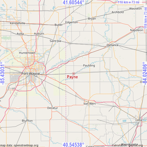
Payne GPS coordinates[2]
41° 4' 39.18" North, 84° 43' 37.848" West
| Map corner | latitude | longitude |
|---|---|---|
| Upper-left | 41.60544°, | -85.43031° |
| Center: | 41.07755°, | -84.72718° |
| Lower-right: | 40.54538°, | -84.02406° |
| Map W x H: | 117.9×117.9 km | = 73.3×73.3mi |
| max Lat: | 71.29058° ⇑33.3% North |
| Payne: | 41.07755° |
| min Lat: | ⇓66.7% South 19.06759° |
| min Long | Payne | max Long |
| -171.73463° | -84.72718° | -66.98998° |
| W 56.6%⇐ | ⇒43.4% E |
Elevation
Elevation of Payne is 229 m = 751 ft, and this is 65.8 m = 216 ft below average elevation for this country.
| Max E: |
3189 m = 10463 ft | 42.3% |
| Avg. | 294.8 m = 967 ft | |
| Payne | 229 m = 751 ft | |
Min E: |
-60 m = -197 ft | 57.7% |
See also: United States elevation on elevation.city.
Geographical zone
Payne is located in North temperate zone (between Tropic of Cancer and the Arctic Circle). Distance of this Northern Tropic circle is 1961.5 km =1218.8 mi to South.| Distance of | km | miles | from Payne |
|---|---|---|---|
| North Pole | 5439.7 | 3380.1 | to North |
| Arctic Circle | 2833.8 | 1760.8 | to North |
| Tropic Cancer | 1961.5 | 1218.8 | to South |
| Equator | 4567.4 | 2838 | to South |


Nearby cities:
15 places around Payne: (largest is in red/bold)
• Antwerp
11.6 km =7.2 mi,  354°
354°
• Convoy
18 km =11.2 mi,  173°
173°
• Decatur
32.3 km =20.1 mi,  211°
211°
• Grabill
25 km =15.5 mi,  306°
306°
• Harlan
20.8 km =12.9 mi, 309°
• Hicksville
24.1 km =15 mi, 353°
• Hoagland
26.5 km =16.5 mi,  236°
236°
• Leo-Cedarville
28.5 km =17.7 mi,  301°
301°
• Monroeville
16.5 km =10.3 mi,  226°
226°
• New Haven
24.1 km =15 mi,  268°
268°
• Oakwood
29.1 km =18.1 mi,  86°
86°
• Paulding
14 km =8.7 mi,  61°
61°
• Sherwood
27.5 km =17.1 mi,  31°
31°
• Van Wert
26.1 km =16.2 mi,  152°
152°
• Woodburn
11.8 km =7.3 mi, 296°
Sources, notices
• [Note1] Compared only with cities in United States existing in our database
• [Src1] Map data: © OpenStreetMap contributors (CC-BY-SA)
• [Src2] Other city data from geonames.org with taken over terms of usage.
• [Src3] Geographical zone / Annual Mean Temperature by Robert A. Rohde @ Wikipedia
