Monon geodata
Monon (Indiana) is a populated place; located in United States in America/Indiana/Indianapolis (GMT-4) time zone. With population of 1,746 people, there are 12753 cities with bigger population in this country. Compared to other cities in United States, 64.2% of cities are located further ↓South; 50.6% of cities are located further ←West and 52.8% of cities have lower elevation than Monon. Note1


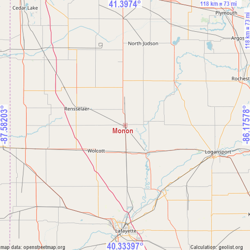
Monon GPS coordinates[2]
40° 52' 4.152" North, 86° 52' 44.04" West
| Map corner | latitude | longitude |
|---|---|---|
| Upper-left | 41.3974°, | -87.58203° |
| Center: | 40.86782°, | -86.8789° |
| Lower-right: | 40.33397°, | -86.17578° |
| Map W x H: | 118.2×118.2 km | = 73.4×73.4mi |
| max Lat: | 71.29058° ⇑35.8% North |
| Monon: | 40.86782° |
| min Lat: | ⇓64.2% South 19.06759° |
| min Long | Monon | max Long |
| -171.73463° | -86.8789° | -66.98998° |
| W 50.6%⇐ | ⇒49.4% E |
Elevation
Elevation of Monon is 209 m = 686 ft, and this is 85.8 m = 281 ft below average elevation for this country.
| Max E: |
3189 m = 10463 ft | 47.2% |
| Avg. | 294.8 m = 967 ft | |
| Monon | 209 m = 686 ft | |
Min E: |
-60 m = -197 ft | 52.8% |
See also: United States elevation on elevation.city.
Geographical zone
Monon is located in North temperate zone (between Tropic of Cancer and the Arctic Circle). Distance of this Northern Tropic circle is 1938.2 km =1204.3 mi to South.| Distance of | km | miles | from Monon |
|---|---|---|---|
| North Pole | 5463 | 3394.5 | to North |
| Arctic Circle | 2857.1 | 1775.3 | to North |
| Tropic Cancer | 1938.2 | 1204.3 | to South |
| Equator | 4544.1 | 2823.6 | to South |


Nearby cities:
15 places around Monon: (largest is in red/bold)
• Brookston
29.5 km =18.3 mi,  178°
178°
• Buffalo
11.4 km =7.1 mi,  81°
81°
• Chalmers
22.8 km =14.2 mi, 177°
• Delphi
35.6 km =22.1 mi,  151°
151°
• Francesville
13.1 km =8.1 mi,  359°
359°
• Georgetown
34.5 km =21.4 mi,  114°
114°
• Goodland
36.8 km =22.9 mi,  251°
251°
• Medaryville
23.7 km =14.7 mi, 357°
• Monticello
16.7 km =10.4 mi,  144°
144°
• Remington
25.8 km =16 mi,  242°
242°
• Rensselaer
24.1 km =15 mi,  288°
288°
• Reynolds
13.2 km =8.2 mi, 177°
• Royal Center
31.9 km =19.8 mi,  90°
90°
• Winamac
30.9 km =19.2 mi,  48°
48°
• Wolcott
18.3 km =11.4 mi,  228°
228°
Sources, notices
• [Note1] Compared only with cities in United States existing in our database
• [Src1] Map data: © OpenStreetMap contributors (CC-BY-SA)
• [Src2] Other city data from geonames.org with taken over terms of usage.
• [Src3] Geographical zone / Annual Mean Temperature by Robert A. Rohde @ Wikipedia
