Delphi geodata
Delphi (Indiana) is a seat of a second-order administrative division; located in United States in America/Indiana/Indianapolis (GMT-4) time zone. With population of 2,858 people, there are 9896 cities with bigger population in this country. Compared to other cities in United States, 59.9% of cities are located further ↓South; 51.1% of cities are located further ←West and 56% of cities have higher elevation than Delphi. Note1
Administrative division(s):
- Level 1: Indiana
- Level 2: Carroll County
- Level 3: Township of Deer Creek


Delphi GPS coordinates[2]
40° 35' 15.144" North, 86° 40' 30.036" West
| Map corner | latitude | longitude |
|---|---|---|
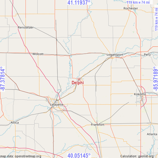
| Upper-left | 41.11937°, | -87.37814° |
| Center: | 40.58754°, | -86.67501° |
| Lower-right: | 40.05145°, | -85.97189° |
| Map W x H: | 118.7×118.7 km | = 73.8×73.8mi |
| max Lat: | 71.29058° ⇑40.1% North |
| Delphi: | 40.58754° |
| min Lat: | ⇓59.9% South 19.06759° |
| min Long | Delphi | max Long |
| -171.73463° | -86.67501° | -66.98998° |
| W 51.1%⇐ | ⇒48.9% E |
Elevation
Elevation of Delphi is 176 m = 577 ft, and this is 118.8 m = 390 ft below average elevation for this country.
| Max E: |
3189 m = 10463 ft | 56% |
| Avg. | 294.8 m = 967 ft | |
| Delphi | 176 m = 577 ft | |
Min E: |
-60 m = -197 ft | 44% |
See also: United States elevation on elevation.city.
Geographical zone
Delphi is located in North temperate zone (between Tropic of Cancer and the Arctic Circle). Distance of this Northern Tropic circle is 1907 km =1185 mi to South.| Distance of | km | miles | from Delphi |
|---|---|---|---|
| North Pole | 5494.2 | 3413.9 | to North |
| Arctic Circle | 2888.3 | 1794.7 | to North |
| Tropic Cancer | 1907 | 1185 | to South |
| Equator | 4512.9 | 2804.2 | to South |


Nearby cities:
15 places around Delphi: (largest is in red/bold)
• Battle Ground
16.6 km =10.3 mi,  237°
237°
• Brookston
16.3 km =10.1 mi,  275°
275°
• Burlington
26.5 km =16.5 mi,  116°
116°
• Camden
11.6 km =7.2 mi,  78°
78°
• Chalmers
18.4 km =11.4 mi,  297°
297°
• Dayton
25 km =15.5 mi,  198°
198°
• Dunkirk
30.3 km =18.8 mi,  51°
51°
• Flora
13.5 km =8.4 mi,  109°
109°
• Georgetown
22.3 km =13.9 mi,  40°
40°
• Lafayette
25.4 km =15.8 mi,  221°
221°
• Monticello
19.1 km =11.9 mi,  336°
336°
• Mulberry
27 km =16.8 mi,  178°
178°
• Reynolds
24.5 km =15.2 mi,  317°
317°
• Rossville
20.1 km =12.5 mi,  160°
160°
• West Lafayette
26.7 km =16.6 mi,  227°
227°
Sources, notices
• [Note1] Compared only with cities in United States existing in our database
• [Src1] Map data: © OpenStreetMap contributors (CC-BY-SA)
• [Src2] Other city data from geonames.org with taken over terms of usage.
• [Src3] Geographical zone / Annual Mean Temperature by Robert A. Rohde @ Wikipedia
