Rolling Prairie geodata
Rolling Prairie (Indiana) is a populated place; located in United States in America/Chicago (GMT-5) time zone. With population of 582 people, there are 19893 cities with bigger population in this country. Compared to other cities in United States, 72.6% of cities are located further ↓South; 51.2% of cities are located further ←West and 62.8% of cities have lower elevation than Rolling Prairie. Note1


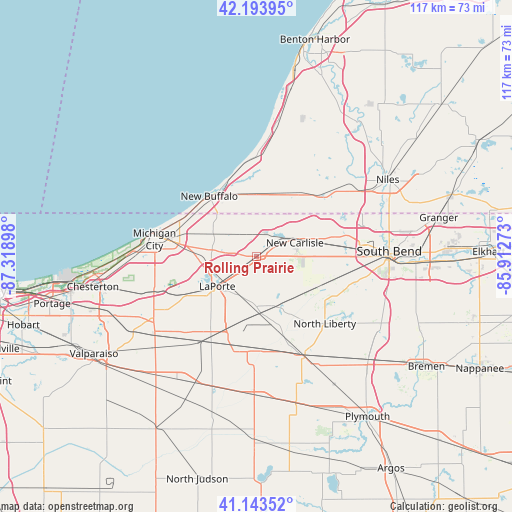
Rolling Prairie GPS coordinates[2]
41° 40' 15.168" North, 86° 36' 57.06" West
| Map corner | latitude | longitude |
|---|---|---|
| Upper-left | 42.19395°, | -87.31898° |
| Center: | 41.67088°, | -86.61585° |
| Lower-right: | 41.14352°, | -85.91273° |
| Map W x H: | 116.8×116.8 km | = 72.6×72.6mi |
| max Lat: | 71.29058° ⇑27.4% North |
| Rolling Prairie: | 41.67088° |
| min Lat: | ⇓72.6% South 19.06759° |
| min Long | Rolling Prairie | max Long |
| -171.73463° | -86.61585° | -66.98998° |
| W 51.2%⇐ | ⇒48.8% E |
Elevation
Elevation of Rolling Prairie is 252 m = 827 ft, and this is 42.8 m = 140 ft below average elevation for this country.
| Max E: |
3189 m = 10463 ft | 37.2% |
| Avg. | 294.8 m = 967 ft | |
| Rolling Prairie | 252 m = 827 ft | |
Min E: |
-60 m = -197 ft | 62.8% |
See also: United States elevation on elevation.city.
Geographical zone
Rolling Prairie is located in North temperate zone (between Tropic of Cancer and the Arctic Circle). Distance of this Northern Tropic circle is 2027.4 km =1259.8 mi to South.| Distance of | km | miles | from Rolling Prairie |
|---|---|---|---|
| North Pole | 5373.7 | 3339.1 | to North |
| Arctic Circle | 2767.8 | 1719.8 | to North |
| Tropic Cancer | 2027.4 | 1259.8 | to South |
| Equator | 4633.4 | 2879.1 | to South |


Nearby cities:
15 places around Rolling Prairie: (largest is in red/bold)
• Fish Lake
12.7 km =7.9 mi,  155°
155°
• Galien
17.1 km =10.6 mi,  34°
34°
• Hamlet
14 km =8.7 mi,  168°
168°
• Hudson Lake
8.1 km =5 mi,  57°
57°
• Kingsford Heights
22.1 km =13.7 mi,  196°
196°
• La Porte
10.8 km =6.7 mi,  229°
229°
• LaPorte
11.1 km =6.9 mi, 232°
• Long Beach
21.4 km =13.3 mi,  290°
290°
• Michigan City
23.5 km =14.6 mi,  279°
279°
• New Buffalo
17.3 km =10.7 mi,  322°
322°
• New Carlisle
9.4 km =5.8 mi,  69°
69°
• North Liberty
21.8 km =13.5 mi,  134°
134°
• Shorewood-Tower Hills-Harbert
23.4 km =14.5 mi,  0°
0°
• Three Oaks
14.2 km =8.8 mi, 1°
• Trail Creek
20.4 km =12.7 mi, 278°
Sources, notices
• [Note1] Compared only with cities in United States existing in our database
• [Src1] Map data: © OpenStreetMap contributors (CC-BY-SA)
• [Src2] Other city data from geonames.org with taken over terms of usage.
• [Src3] Geographical zone / Annual Mean Temperature by Robert A. Rohde @ Wikipedia
