Boston geodata
Boston (Massachusetts) is a seat of a first-order administrative division; located in United States in America/New_York (GMT-4) time zone. With population of 667,137 people, there are 25 cities with bigger population in this country. Compared to other cities in United States, 78.6% of cities are located further ↓South; 97.5% of cities are located further ←West and 82.1% of cities have higher elevation than Boston. Note1


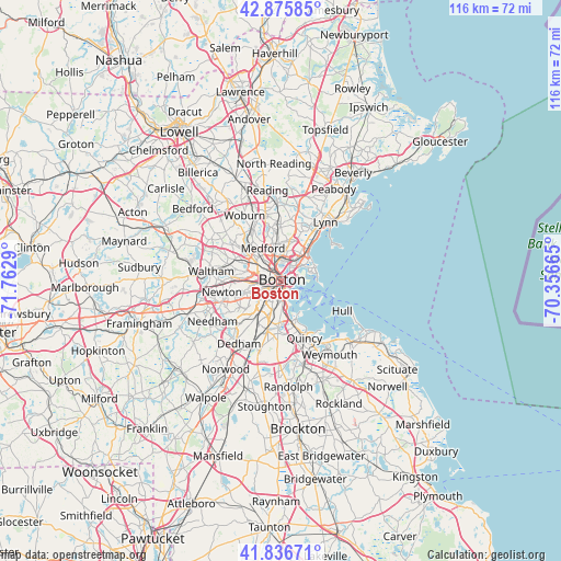
Boston GPS coordinates[2]
42° 21' 30.348" North, 71° 3' 35.172" West
| Map corner | latitude | longitude |
|---|---|---|
| Upper-left | 42.87585°, | -71.7629° |
| Center: | 42.35843°, | -71.05977° |
| Lower-right: | 41.83671°, | -70.35665° |
| Map W x H: | 115.5×115.5 km | = 71.8×71.8mi |
| max Lat: | 71.29058° ⇑21.4% North |
| Boston: | 42.35843° |
| min Lat: | ⇓78.6% South 19.06759° |
| min Long | Boston | max Long |
| -171.73463° | -71.05977° | -66.98998° |
| W 97.5%⇐ | ⇒2.5% E |
Elevation
Elevation of Boston is 38 m = 125 ft, and this is 256.8 m = 843 ft below average elevation for this country.
| Max E: |
3189 m = 10463 ft | 82.1% |
| Avg. | 294.8 m = 967 ft | |
| Boston | 38 m = 125 ft | |
Min E: |
-60 m = -197 ft | 17.9% |
See also: Boston elevation on elevation.city.
Geographical zone
Boston is located in North temperate zone (between Tropic of Cancer and the Arctic Circle). Distance of this Northern Tropic circle is 2103.9 km =1307.3 mi to South.| Distance of | km | miles | from Boston |
|---|---|---|---|
| North Pole | 5297.2 | 3291.5 | to North |
| Arctic Circle | 2691.4 | 1672.4 | to North |
| Tropic Cancer | 2103.9 | 1307.3 | to South |
| Equator | 4709.8 | 2926.5 | to South |


Nearby cities:
15 places around Boston: (largest is in red/bold)
• Arlington
10.2 km =6.3 mi,  308°
308°
• Belmont
10.6 km =6.6 mi,  293°
293°
• Brookline
5.9 km =3.7 mi,  239°
239°
• Cambridge
4.2 km =2.6 mi,  296°
296°
• Chelsea
4.3 km =2.7 mi,  30°
30°
• Everett
5.6 km =3.5 mi,  5°
5°
• Jamaica Plain
7.3 km =4.5 mi,  222°
222°
• Malden
7.4 km =4.6 mi,  355°
355°
• Medford
7.7 km =4.8 mi,  330°
330°
• Melrose
11.1 km =6.9 mi, 357°
• Revere
6.8 km =4.2 mi,  35°
35°
• Somerville
4.6 km =2.9 mi, 314°
• South Boston
2.9 km =1.8 mi,  163°
163°
• Watertown
10.2 km =6.3 mi,  277°
277°
• Winthrop
6.6 km =4.1 mi,  73°
73°
Sources, notices
• [Note1] Compared only with cities in United States existing in our database
• [Src1] Map data: © OpenStreetMap contributors (CC-BY-SA)
• [Src2] Other city data from geonames.org with taken over terms of usage.
• [Src3] Geographical zone / Annual Mean Temperature by Robert A. Rohde @ Wikipedia
