Revere geodata
Revere (Massachusetts) is a populated place; located in United States in America/New_York (GMT-4) time zone. With population of 53,422 people, there are 873 cities with bigger population in this country. Compared to other cities in United States, 79% of cities are located further ↓South; 97.6% of cities are located further ←West and 95.7% of cities have higher elevation than Revere. Note1


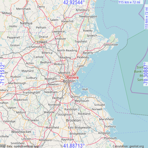
Revere GPS coordinates[2]
42° 24' 30.348" North, 71° 0' 43.164" West
| Map corner | latitude | longitude |
|---|---|---|
| Upper-left | 42.92544°, | -71.71512° |
| Center: | 42.40843°, | -71.01199° |
| Lower-right: | 41.88713°, | -70.30887° |
| Map W x H: | 115.4×115.4 km | = 71.7×71.7mi |
| max Lat: | 71.29058° ⇑21% North |
| Revere: | 42.40843° |
| min Lat: | ⇓79% South 19.06759° |
| min Long | Revere | max Long |
| -171.73463° | -71.01199° | -66.98998° |
| W 97.6%⇐ | ⇒2.4% E |
Elevation
Elevation of Revere is 8 m = 26 ft, and this is 286.8 m = 941 ft below average elevation for this country.
| Max E: |
3189 m = 10463 ft | 95.7% |
| Avg. | 294.8 m = 967 ft | |
| Revere | 8 m = 26 ft | |
Min E: |
-60 m = -197 ft | 4.3% |
See also: Revere elevation on elevation.city.
Geographical zone
Revere is located in North temperate zone (between Tropic of Cancer and the Arctic Circle). Distance of this Northern Tropic circle is 2109.5 km =1310.8 mi to South.| Distance of | km | miles | from Revere |
|---|---|---|---|
| North Pole | 5291.7 | 3288.1 | to North |
| Arctic Circle | 2685.8 | 1668.9 | to North |
| Tropic Cancer | 2109.5 | 1310.8 | to South |
| Equator | 4715.4 | 2930 | to South |


Nearby cities:
15 places around Revere: (largest is in red/bold)
• Boston
6.8 km =4.2 mi,  215°
215°
• Cambridge
8.5 km =5.3 mi,  244°
244°
• Chelsea
2.5 km =1.6 mi, 222°
• Everett
3.4 km =2.1 mi,  270°
270°
• Lynn
8.3 km =5.2 mi,  38°
38°
• Malden
4.8 km =3 mi,  292°
292°
• Medford
7.8 km =4.8 mi,  278°
278°
• Melrose
7.1 km =4.4 mi,  321°
321°
• Nahant
7.9 km =4.9 mi,  75°
75°
• Saugus
6.3 km =3.9 mi,  1°
1°
• Somerville
7.5 km =4.7 mi,  252°
252°
• South Boston
8.9 km =5.5 mi,  200°
200°
• Stoneham
10.7 km =6.6 mi, 317°
• Swampscott
10.4 km =6.5 mi,  48°
48°
• Winthrop
4.4 km =2.7 mi,  147°
147°
Sources, notices
• [Note1] Compared only with cities in United States existing in our database
• [Src1] Map data: © OpenStreetMap contributors (CC-BY-SA)
• [Src2] Other city data from geonames.org with taken over terms of usage.
• [Src3] Geographical zone / Annual Mean Temperature by Robert A. Rohde @ Wikipedia
