Everett geodata
Everett (Massachusetts) is a populated place; located in United States in America/New_York (GMT-4) time zone. With population of 46,050 people, there are 1040 cities with bigger population in this country. Compared to other cities in United States, 79% of cities are located further ↓South; 97.5% of cities are located further ←West and 87.4% of cities have higher elevation than Everett. Note1
Administrative division(s):
- Level 1: Massachusetts
- Level 2: Middlesex County
- Level 3: City of Everett


Everett GPS coordinates[2]
42° 24' 30.348" North, 71° 3' 13.176" West
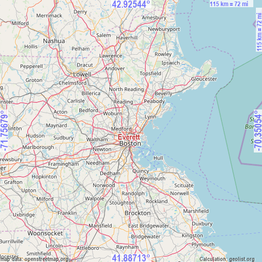
| Map corner | latitude | longitude |
|---|---|---|
| Upper-left | 42.92544°, | -71.75679° |
| Center: | 42.40843°, | -71.05366° |
| Lower-right: | 41.88713°, | -70.35054° |
| Map W x H: | 115.4×115.4 km | = 71.7×71.7mi |
| max Lat: | 71.29058° ⇑21% North |
| Everett: | 42.40843° |
| min Lat: | ⇓79% South 19.06759° |
| min Long | Everett | max Long |
| -171.73463° | -71.05366° | -66.98998° |
| W 97.5%⇐ | ⇒2.5% E |
Elevation
Elevation of Everett is 22 m = 72 ft, and this is 272.8 m = 895 ft below average elevation for this country.
| Max E: |
3189 m = 10463 ft | 87.4% |
| Avg. | 294.8 m = 967 ft | |
| Everett | 22 m = 72 ft | |
Min E: |
-60 m = -197 ft | 12.6% |
See also: Everett elevation on elevation.city.
Geographical zone
Everett is located in North temperate zone (between Tropic of Cancer and the Arctic Circle). Distance of this Northern Tropic circle is 2109.5 km =1310.8 mi to South.| Distance of | km | miles | from Everett |
|---|---|---|---|
| North Pole | 5291.7 | 3288.1 | to North |
| Arctic Circle | 2685.8 | 1668.9 | to North |
| Tropic Cancer | 2109.5 | 1310.8 | to South |
| Equator | 4715.4 | 2930 | to South |


Nearby cities:
15 places around Everett: (largest is in red/bold)
• Arlington
8.5 km =5.3 mi,  275°
275°
• Boston
5.6 km =3.5 mi,  185°
185°
• Brookline
10.2 km =6.3 mi,  213°
213°
• Cambridge
5.7 km =3.5 mi,  229°
229°
• Chelsea
2.5 km =1.6 mi,  137°
137°
• Malden
2.1 km =1.3 mi,  331°
331°
• Medford
4.5 km =2.8 mi, 284°
• Melrose
5.7 km =3.5 mi,  349°
349°
• Revere
3.4 km =2.1 mi,  90°
90°
• Saugus
7.2 km =4.5 mi,  29°
29°
• Somerville
4.4 km =2.7 mi,  238°
238°
• South Boston
8.3 km =5.2 mi,  177°
177°
• Stoneham
8.8 km =5.5 mi, 334°
• Winchester
8.4 km =5.2 mi,  305°
305°
• Winthrop
6.9 km =4.3 mi,  122°
122°
Sources, notices
• [Note1] Compared only with cities in United States existing in our database
• [Src1] Map data: © OpenStreetMap contributors (CC-BY-SA)
• [Src2] Other city data from geonames.org with taken over terms of usage.
• [Src3] Geographical zone / Annual Mean Temperature by Robert A. Rohde @ Wikipedia
