Taunton geodata
Taunton (Massachusetts) is a seat of a second-order administrative division; located in United States in America/New_York (GMT-4) time zone. With population of 56,789 people, there are 803 cities with bigger population in this country. Compared to other cities in United States, 74.8% of cities are located further ↓South; 97.4% of cities are located further ←West and 99.9% of cities have higher elevation than Taunton. Note1


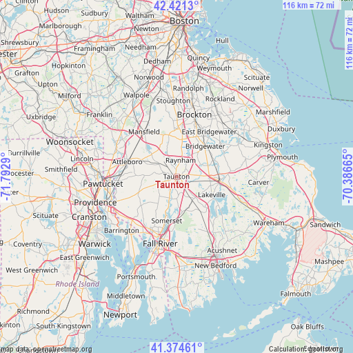
Taunton GPS coordinates[2]
41° 54' 0.36" North, 71° 5' 23.172" West
| Map corner | latitude | longitude |
|---|---|---|
| Upper-left | 42.4213°, | -71.7929° |
| Center: | 41.9001°, | -71.08977° |
| Lower-right: | 41.37461°, | -70.38665° |
| Map W x H: | 116.4×116.4 km | = 72.3×72.3mi |
| max Lat: | 71.29058° ⇑25.2% North |
| Taunton: | 41.9001° |
| min Lat: | ⇓74.8% South 19.06759° |
| min Long | Taunton | max Long |
| -171.73463° | -71.08977° | -66.98998° |
| W 97.4%⇐ | ⇒2.6% E |
Elevation
Elevation of Taunton is -16 m = -52 ft, and this is 310.8 m = 1020 ft below average elevation for this country.
| Max E: |
3189 m = 10463 ft | 99.9% |
| Avg. | 294.8 m = 967 ft | |
| Taunton | -16 m = -52 ft | |
Min E: |
-60 m = -197 ft | 0.1% |
See also: Taunton elevation on elevation.city.
Geographical zone
Taunton is located in North temperate zone (between Tropic of Cancer and the Arctic Circle). Distance of this Northern Tropic circle is 2052.9 km =1275.6 mi to South.| Distance of | km | miles | from Taunton |
|---|---|---|---|
| North Pole | 5348.2 | 3323.2 | to North |
| Arctic Circle | 2742.3 | 1704 | to North |
| Tropic Cancer | 2052.9 | 1275.6 | to South |
| Equator | 4658.9 | 2894.9 | to South |


Nearby cities:
15 places around Taunton: (largest is in red/bold)
• Assonet
11.7 km =7.3 mi,  171°
171°
• Berkley
6.1 km =3.8 mi, 174°
• Bridgewater
13.8 km =8.6 mi,  43°
43°
• Dighton
9.9 km =6.2 mi,  194°
194°
• Easton
14.2 km =8.8 mi,  346°
346°
• Middleborough
14.8 km =9.2 mi,  92°
92°
• Middleborough Center
13.6 km =8.5 mi, 92°
• North Lakeville
13.1 km =8.1 mi,  111°
111°
• Norton
10.9 km =6.8 mi,  312°
312°
• Norton Center
11.3 km =7 mi,  315°
315°
• Raynham
5.6 km =3.5 mi,  14°
14°
• Raynham Center
4.1 km =2.5 mi,  49°
49°
• Rehoboth
14.8 km =9.2 mi,  243°
243°
• Somerset
14.9 km =9.3 mi, 192°
• West Bridgewater
14.9 km =9.3 mi,  27°
27°
Sources, notices
• [Note1] Compared only with cities in United States existing in our database
• [Src1] Map data: © OpenStreetMap contributors (CC-BY-SA)
• [Src2] Other city data from geonames.org with taken over terms of usage.
• [Src3] Geographical zone / Annual Mean Temperature by Robert A. Rohde @ Wikipedia
