Dedham geodata
Dedham (Massachusetts) is a seat of a second-order administrative division; located in United States in America/New_York (GMT-4) time zone. With population of 24,729 people, there are 2038 cities with bigger population in this country. Compared to other cities in United States, 77.7% of cities are located further ↓South; 97.3% of cities are located further ←West and 81.6% of cities have higher elevation than Dedham. Note1


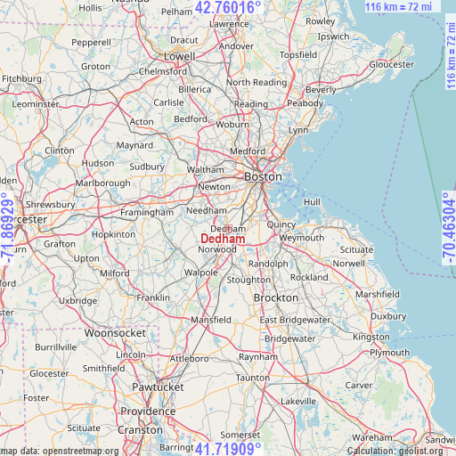
Dedham GPS coordinates[2]
42° 14' 30.372" North, 71° 9' 58.176" West
| Map corner | latitude | longitude |
|---|---|---|
| Upper-left | 42.76016°, | -71.86929° |
| Center: | 42.24177°, | -71.16616° |
| Lower-right: | 41.71909°, | -70.46304° |
| Map W x H: | 115.8×115.8 km | = 72×72mi |
| max Lat: | 71.29058° ⇑22.3% North |
| Dedham: | 42.24177° |
| min Lat: | ⇓77.7% South 19.06759° |
| min Long | Dedham | max Long |
| -171.73463° | -71.16616° | -66.98998° |
| W 97.3%⇐ | ⇒2.7% E |
Elevation
Elevation of Dedham is 40 m = 131 ft, and this is 254.8 m = 836 ft below average elevation for this country.
| Max E: |
3189 m = 10463 ft | 81.6% |
| Avg. | 294.8 m = 967 ft | |
| Dedham | 40 m = 131 ft | |
Min E: |
-60 m = -197 ft | 18.4% |
See also: United States elevation on elevation.city.
Geographical zone
Dedham is located in North temperate zone (between Tropic of Cancer and the Arctic Circle). Distance of this Northern Tropic circle is 2090.9 km =1299.2 mi to South.| Distance of | km | miles | from Dedham |
|---|---|---|---|
| North Pole | 5310.2 | 3299.6 | to North |
| Arctic Circle | 2704.3 | 1680.4 | to North |
| Tropic Cancer | 2090.9 | 1299.2 | to South |
| Equator | 4696.8 | 2918.5 | to South |


Nearby cities:
15 places around Dedham: (largest is in red/bold)
• Brookline
10.7 km =6.6 mi,  20°
20°
• Canton
9.4 km =5.8 mi,  169°
169°
• Dover
9.6 km =6 mi,  272°
272°
• Jamaica Plain
8.5 km =5.3 mi,  26°
26°
• Medfield
13 km =8.1 mi,  242°
242°
• Milton
8.3 km =5.2 mi,  84°
84°
• Needham
7.2 km =4.5 mi,  310°
310°
• Newton
11.2 km =7 mi,  341°
341°
• Norwood
5.9 km =3.7 mi,  207°
207°
• Quincy
13.5 km =8.4 mi, 84°
• Randolph
13.5 km =8.4 mi,  130°
130°
• Sharon
13.2 km =8.2 mi,  184°
184°
• Walpole
13.1 km =8.1 mi, 211°
• Wellesley
12 km =7.5 mi,  300°
300°
• Westwood
5.7 km =3.5 mi, 237°
Sources, notices
• [Note1] Compared only with cities in United States existing in our database
• [Src1] Map data: © OpenStreetMap contributors (CC-BY-SA)
• [Src2] Other city data from geonames.org with taken over terms of usage.
• [Src3] Geographical zone / Annual Mean Temperature by Robert A. Rohde @ Wikipedia
