Fitchburg geodata
Fitchburg (Massachusetts) is a populated place; located in United States in America/New_York (GMT-4) time zone. With population of 40,545 people, there are 1193 cities with bigger population in this country. Compared to other cities in United States, 80.4% of cities are located further ↓South; 96% of cities are located further ←West and 62.1% of cities have higher elevation than Fitchburg. Note1
Administrative division(s):
- Level 1: Massachusetts
- Level 2: Worcester County
- Level 3: City of Fitchburg


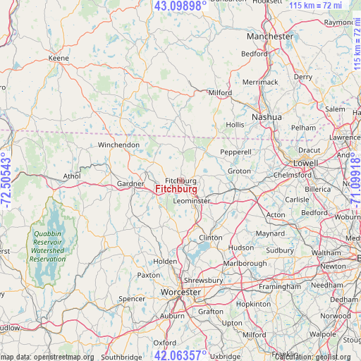
Fitchburg GPS coordinates[2]
42° 35' 0.312" North, 71° 48' 8.28" West
| Map corner | latitude | longitude |
|---|---|---|
| Upper-left | 43.09898°, | -72.50543° |
| Center: | 42.58342°, | -71.8023° |
| Lower-right: | 42.06357°, | -71.09918° |
| Map W x H: | 115.1×115.1 km | = 71.5×71.5mi |
| max Lat: | 71.29058° ⇑19.6% North |
| Fitchburg: | 42.58342° |
| min Lat: | ⇓80.4% South 19.06759° |
| min Long | Fitchburg | max Long |
| -171.73463° | -71.8023° | -66.98998° |
| W 96%⇐ | ⇒4% E |
Elevation
Elevation of Fitchburg is 144 m = 472 ft, and this is 150.8 m = 495 ft below average elevation for this country.
| Max E: |
3189 m = 10463 ft | 62.1% |
| Avg. | 294.8 m = 967 ft | |
| Fitchburg | 144 m = 472 ft | |
Min E: |
-60 m = -197 ft | 37.9% |
See also: Fitchburg elevation on elevation.city.
Geographical zone
Fitchburg is located in North temperate zone (between Tropic of Cancer and the Arctic Circle). Distance of this Northern Tropic circle is 2128.9 km =1322.8 mi to South.| Distance of | km | miles | from Fitchburg |
|---|---|---|---|
| North Pole | 5272.2 | 3276 | to North |
| Arctic Circle | 2666.3 | 1656.8 | to North |
| Tropic Cancer | 2128.9 | 1322.8 | to South |
| Equator | 4734.8 | 2942.1 | to South |


Nearby cities:
15 places around Fitchburg: (largest is in red/bold)
• Ashburnham
10.4 km =6.5 mi,  304°
304°
• Ashby
10.6 km =6.6 mi,  351°
351°
• Ayer
17.6 km =10.9 mi,  98°
98°
• Devens
16.1 km =10 mi,  105°
105°
• Gardner
16.1 km =10 mi,  266°
266°
• Lancaster
17.7 km =11 mi,  143°
143°
• Leominster
7.4 km =4.6 mi,  151°
151°
• Lunenburg
6.5 km =4 mi,  79°
79°
• Mason
18 km =11.2 mi,  8°
8°
• Princeton
16.2 km =10.1 mi,  202°
202°
• Shirley
13.3 km =8.3 mi, 109°
• South Ashburnham
11.6 km =7.2 mi,  284°
284°
• Sterling
16.6 km =10.3 mi,  168°
168°
• Townsend
12.2 km =7.6 mi,  40°
40°
• Westminster
9.8 km =6.1 mi,  244°
244°
Sources, notices
• [Note1] Compared only with cities in United States existing in our database
• [Src1] Map data: © OpenStreetMap contributors (CC-BY-SA)
• [Src2] Other city data from geonames.org with taken over terms of usage.
• [Src3] Geographical zone / Annual Mean Temperature by Robert A. Rohde @ Wikipedia
