Holyoke geodata
Holyoke (Massachusetts) is a populated place; located in United States in America/New_York (GMT-4) time zone. With population of 40,684 people, there are 1188 cities with bigger population in this country. Compared to other cities in United States, 77.4% of cities are located further ↓South; 94.6% of cities are located further ←West and 76.9% of cities have higher elevation than Holyoke. Note1


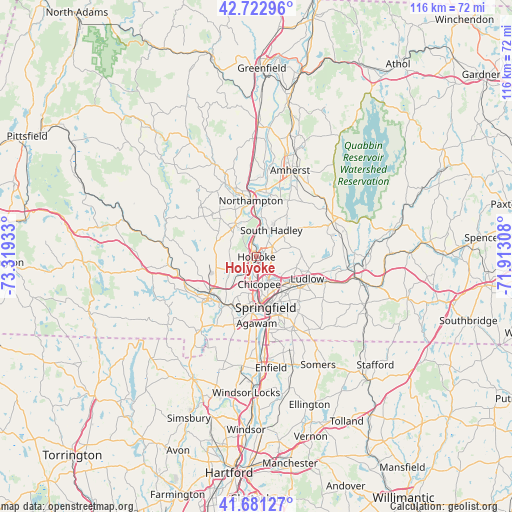
Holyoke GPS coordinates[2]
42° 12' 15.336" North, 72° 36' 58.32" West
| Map corner | latitude | longitude |
|---|---|---|
| Upper-left | 42.72296°, | -73.31933° |
| Center: | 42.20426°, | -72.6162° |
| Lower-right: | 41.68127°, | -71.91308° |
| Map W x H: | 115.8×115.8 km | = 72×72mi |
| max Lat: | 71.29058° ⇑22.6% North |
| Holyoke: | 42.20426° |
| min Lat: | ⇓77.4% South 19.06759° |
| min Long | Holyoke | max Long |
| -171.73463° | -72.6162° | -66.98998° |
| W 94.6%⇐ | ⇒5.4% E |
Elevation
Elevation of Holyoke is 61 m = 200 ft, and this is 233.8 m = 767 ft below average elevation for this country.
| Max E: |
3189 m = 10463 ft | 76.9% |
| Avg. | 294.8 m = 967 ft | |
| Holyoke | 61 m = 200 ft | |
Min E: |
-60 m = -197 ft | 23.1% |
See also: Holyoke elevation on elevation.city.
Geographical zone
Holyoke is located in North temperate zone (between Tropic of Cancer and the Arctic Circle). Distance of this Northern Tropic circle is 2086.8 km =1296.7 mi to South.| Distance of | km | miles | from Holyoke |
|---|---|---|---|
| North Pole | 5314.4 | 3302.2 | to North |
| Arctic Circle | 2708.5 | 1683 | to North |
| Tropic Cancer | 2086.8 | 1296.7 | to South |
| Equator | 4692.7 | 2915.9 | to South |


Nearby cities:
15 places around Holyoke: (largest is in red/bold)
• Agawam
15 km =9.3 mi,  179°
179°
• Chicopee
6.2 km =3.9 mi,  173°
173°
• Easthampton
8.2 km =5.1 mi,  327°
327°
• Granby
10.1 km =6.3 mi,  54°
54°
• Hadley
15.5 km =9.6 mi,  8°
8°
• Ludlow
12.6 km =7.8 mi,  113°
113°
• Montgomery
15.6 km =9.7 mi,  271°
271°
• North Chicopee
2.7 km =1.7 mi,  149°
149°
• Northampton
13.6 km =8.5 mi,  351°
351°
• South Hadley
6.9 km =4.3 mi,  29°
29°
• Southampton
9.8 km =6.1 mi,  286°
286°
• Springfield
11.6 km =7.2 mi, 169°
• West Springfield
10.8 km =6.7 mi, 181°
• Westfield
14.1 km =8.8 mi,  231°
231°
• Westhampton
17 km =10.6 mi,  310°
310°
Sources, notices
• [Note1] Compared only with cities in United States existing in our database
• [Src1] Map data: © OpenStreetMap contributors (CC-BY-SA)
• [Src2] Other city data from geonames.org with taken over terms of usage.
• [Src3] Geographical zone / Annual Mean Temperature by Robert A. Rohde @ Wikipedia
