Ludlow geodata
Ludlow (Massachusetts) is a populated place; located in United States in America/New_York (GMT-4) time zone. With population of 22,201 people, there are 2279 cities with bigger population in this country. Compared to other cities in United States, 77% of cities are located further ↓South; 94.9% of cities are located further ←West and 74% of cities have higher elevation than Ludlow. Note1


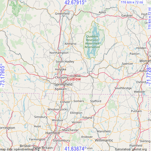
Ludlow GPS coordinates[2]
42° 9' 36.324" North, 72° 28' 33.312" West
| Map corner | latitude | longitude |
|---|---|---|
| Upper-left | 42.67915°, | -73.17905° |
| Center: | 42.16009°, | -72.47592° |
| Lower-right: | 41.63674°, | -71.7728° |
| Map W x H: | 115.9×115.9 km | = 72×72mi |
| max Lat: | 71.29058° ⇑23% North |
| Ludlow: | 42.16009° |
| min Lat: | ⇓77% South 19.06759° |
| min Long | Ludlow | max Long |
| -171.73463° | -72.47592° | -66.98998° |
| W 94.9%⇐ | ⇒5.1% E |
Elevation
Elevation of Ludlow is 77 m = 253 ft, and this is 217.8 m = 715 ft below average elevation for this country.
| Max E: |
3189 m = 10463 ft | 74% |
| Avg. | 294.8 m = 967 ft | |
| Ludlow | 77 m = 253 ft | |
Min E: |
-60 m = -197 ft | 26% |
See also: United States elevation on elevation.city.
Geographical zone
Ludlow is located in North temperate zone (between Tropic of Cancer and the Arctic Circle). Distance of this Northern Tropic circle is 2081.8 km =1293.6 mi to South.| Distance of | km | miles | from Ludlow |
|---|---|---|---|
| North Pole | 5319.3 | 3305.3 | to North |
| Arctic Circle | 2713.4 | 1686 | to North |
| Tropic Cancer | 2081.8 | 1293.6 | to South |
| Equator | 4687.8 | 2912.9 | to South |


Nearby cities:
15 places around Ludlow: (largest is in red/bold)
• Belchertown
14.4 km =8.9 mi,  25°
25°
• Bondsville
12.2 km =7.6 mi,  61°
61°
• Chicopee
11 km =6.8 mi,  263°
263°
• East Longmeadow
11 km =6.8 mi,  195°
195°
• Granby
11.2 km =7 mi,  342°
342°
• Hampden
11.9 km =7.4 mi,  154°
154°
• Holyoke
12.6 km =7.8 mi,  293°
293°
• Monson
14.4 km =8.9 mi,  115°
115°
• North Chicopee
10.5 km =6.5 mi,  284°
284°
• Palmer
12.1 km =7.5 mi,  90°
90°
• South Hadley
13.6 km =8.5 mi,  323°
323°
• Springfield
11.4 km =7.1 mi,  235°
235°
• Three Rivers
9.8 km =6.1 mi,  76°
76°
• West Springfield
13.3 km =8.3 mi, 243°
• Wilbraham
5.5 km =3.4 mi,  137°
137°
Sources, notices
• [Note1] Compared only with cities in United States existing in our database
• [Src1] Map data: © OpenStreetMap contributors (CC-BY-SA)
• [Src2] Other city data from geonames.org with taken over terms of usage.
• [Src3] Geographical zone / Annual Mean Temperature by Robert A. Rohde @ Wikipedia
