Westfield geodata
Westfield (Massachusetts) is a populated place; located in United States in America/New_York (GMT-4) time zone. With population of 41,690 people, there are 1150 cities with bigger population in this country. Compared to other cities in United States, 76.8% of cities are located further ↓South; 94.3% of cities are located further ←West and 79.9% of cities have higher elevation than Westfield. Note1
Administrative division(s):
- Level 1: Massachusetts
- Level 2: Hampden County
- Level 3: City of Westfield


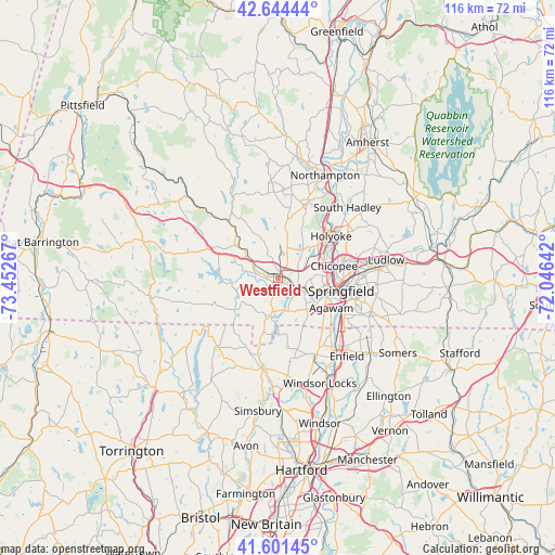
Westfield GPS coordinates[2]
42° 7' 30.324" North, 72° 44' 58.344" West
| Map corner | latitude | longitude |
|---|---|---|
| Upper-left | 42.64444°, | -73.45267° |
| Center: | 42.12509°, | -72.74954° |
| Lower-right: | 41.60145°, | -72.04642° |
| Map W x H: | 116×116 km | = 72.1×72.1mi |
| max Lat: | 71.29058° ⇑23.2% North |
| Westfield: | 42.12509° |
| min Lat: | ⇓76.8% South 19.06759° |
| min Long | Westfield | max Long |
| -171.73463° | -72.74954° | -66.98998° |
| W 94.3%⇐ | ⇒5.7% E |
Elevation
Elevation of Westfield is 47 m = 154 ft, and this is 247.8 m = 813 ft below average elevation for this country.
| Max E: |
3189 m = 10463 ft | 79.9% |
| Avg. | 294.8 m = 967 ft | |
| Westfield | 47 m = 154 ft | |
Min E: |
-60 m = -197 ft | 20.1% |
See also: Westfield elevation on elevation.city.
Geographical zone
Westfield is located in North temperate zone (between Tropic of Cancer and the Arctic Circle). Distance of this Northern Tropic circle is 2078 km =1291.2 mi to South.| Distance of | km | miles | from Westfield |
|---|---|---|---|
| North Pole | 5323.2 | 3307.7 | to North |
| Arctic Circle | 2717.3 | 1688.5 | to North |
| Tropic Cancer | 2078 | 1291.2 | to South |
| Equator | 4683.9 | 2910.4 | to South |


Nearby cities:
15 places around Westfield: (largest is in red/bold)
• Agawam
12.7 km =7.9 mi,  119°
119°
• Chicopee
12 km =7.5 mi,  77°
77°
• Easthampton
17.1 km =10.6 mi,  22°
22°
• Granville
11.3 km =7 mi,  234°
234°
• Holyoke
14.1 km =8.8 mi,  51°
51°
• Huntington
16.2 km =10.1 mi,  319°
319°
• Longmeadow
16.1 km =10 mi, 121°
• Montgomery
10.2 km =6.3 mi,  333°
333°
• North Chicopee
14 km =8.7 mi,  62°
62°
• North Granby
15.8 km =9.8 mi,  204°
204°
• Russell
11.6 km =7.2 mi,  308°
308°
• Southampton
11.7 km =7.3 mi,  7°
7°
• Southwick
8 km =5 mi,  192°
192°
• Springfield
13.4 km =8.3 mi,  101°
101°
• West Springfield
10.8 km =6.7 mi, 100°
Sources, notices
• [Note1] Compared only with cities in United States existing in our database
• [Src1] Map data: © OpenStreetMap contributors (CC-BY-SA)
• [Src2] Other city data from geonames.org with taken over terms of usage.
• [Src3] Geographical zone / Annual Mean Temperature by Robert A. Rohde @ Wikipedia
