Lynn geodata
Lynn (Massachusetts) is a populated place; located in United States in America/New_York (GMT-4) time zone. With population of 92,457 people, there are 397 cities with bigger population in this country. Compared to other cities in United States, 79.5% of cities are located further ↓South; 97.7% of cities are located further ←West and 89.5% of cities have higher elevation than Lynn. Note1


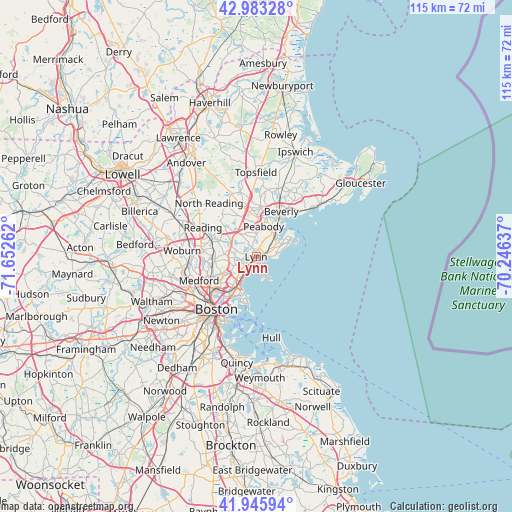
Lynn GPS coordinates[2]
42° 28' 0.336" North, 70° 56' 58.164" West
| Map corner | latitude | longitude |
|---|---|---|
| Upper-left | 42.98328°, | -71.65262° |
| Center: | 42.46676°, | -70.94949° |
| Lower-right: | 41.94594°, | -70.24637° |
| Map W x H: | 115.3×115.3 km | = 71.6×71.6mi |
| max Lat: | 71.29058° ⇑20.5% North |
| Lynn: | 42.46676° |
| min Lat: | ⇓79.5% South 19.06759° |
| min Long | Lynn | max Long |
| -171.73463° | -70.94949° | -66.98998° |
| W 97.7%⇐ | ⇒2.3% E |
Elevation
Elevation of Lynn is 17 m = 56 ft, and this is 277.8 m = 911 ft below average elevation for this country.
| Max E: |
3189 m = 10463 ft | 89.5% |
| Avg. | 294.8 m = 967 ft | |
| Lynn | 17 m = 56 ft | |
Min E: |
-60 m = -197 ft | 10.5% |
See also: Lynn elevation on elevation.city.
Geographical zone
Lynn is located in North temperate zone (between Tropic of Cancer and the Arctic Circle). Distance of this Northern Tropic circle is 2115.9 km =1314.8 mi to South.| Distance of | km | miles | from Lynn |
|---|---|---|---|
| North Pole | 5285.2 | 3284.1 | to North |
| Arctic Circle | 2679.3 | 1664.8 | to North |
| Tropic Cancer | 2115.9 | 1314.8 | to South |
| Equator | 4721.9 | 2934.1 | to South |


Nearby cities:
15 places around Lynn: (largest is in red/bold)
• Chelsea
10.8 km =6.7 mi,  219°
219°
• Everett
10.7 km =6.6 mi,  232°
232°
• Lynnfield
11.4 km =7.1 mi,  314°
314°
• Malden
10.6 km =6.6 mi,  244°
244°
• Marblehead
8.4 km =5.2 mi,  63°
63°
• Melrose
9.6 km =6 mi,  264°
264°
• Nahant
5.1 km =3.2 mi,  150°
150°
• Peabody
7 km =4.3 mi,  14°
14°
• Revere
8.3 km =5.2 mi, 218°
• Salem
7.3 km =4.5 mi,  36°
36°
• Saugus
5 km =3.1 mi,  267°
267°
• South Peabody
4.8 km =3 mi,  0°
0°
• Swampscott
2.7 km =1.7 mi,  79°
79°
• Wakefield
11 km =6.8 mi,  293°
293°
• Winthrop
10.6 km =6.6 mi,  195°
195°
Sources, notices
• [Note1] Compared only with cities in United States existing in our database
• [Src1] Map data: © OpenStreetMap contributors (CC-BY-SA)
• [Src2] Other city data from geonames.org with taken over terms of usage.
• [Src3] Geographical zone / Annual Mean Temperature by Robert A. Rohde @ Wikipedia
