Peabody geodata
Peabody (Massachusetts) is a populated place; located in United States in America/New_York (GMT-4) time zone. With population of 52,504 people, there are 891 cities with bigger population in this country. Compared to other cities in United States, 80% of cities are located further ↓South; 97.8% of cities are located further ←West and 92.1% of cities have higher elevation than Peabody. Note1


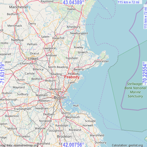
Peabody GPS coordinates[2]
42° 31' 40.332" North, 70° 55' 43.176" West
| Map corner | latitude | longitude |
|---|---|---|
| Upper-left | 43.04389°, | -71.63179° |
| Center: | 42.52787°, | -70.92866° |
| Lower-right: | 42.00756°, | -70.22554° |
| Map W x H: | 115.2×115.2 km | = 71.6×71.6mi |
| max Lat: | 71.29058° ⇑20% North |
| Peabody: | 42.52787° |
| min Lat: | ⇓80% South 19.06759° |
| min Long | Peabody | max Long |
| -171.73463° | -70.92866° | -66.98998° |
| W 97.8%⇐ | ⇒2.2% E |
Elevation
Elevation of Peabody is 12 m = 39 ft, and this is 282.8 m = 928 ft below average elevation for this country.
| Max E: |
3189 m = 10463 ft | 92.1% |
| Avg. | 294.8 m = 967 ft | |
| Peabody | 12 m = 39 ft | |
Min E: |
-60 m = -197 ft | 7.9% |
See also: Peabody elevation on elevation.city.
Geographical zone
Peabody is located in North temperate zone (between Tropic of Cancer and the Arctic Circle). Distance of this Northern Tropic circle is 2122.7 km =1319 mi to South.| Distance of | km | miles | from Peabody |
|---|---|---|---|
| North Pole | 5278.4 | 3279.8 | to North |
| Arctic Circle | 2672.5 | 1660.6 | to North |
| Tropic Cancer | 2122.7 | 1319 | to South |
| Equator | 4728.7 | 2938.3 | to South |


Nearby cities:
15 places around Peabody: (largest is in red/bold)
• Beverly
5.2 km =3.2 mi,  49°
49°
• Beverly Cove
6.8 km =4.2 mi,  65°
65°
• Danvers
5.3 km =3.3 mi,  358°
358°
• Lynn
7 km =4.3 mi,  194°
194°
• Lynnfield
9.9 km =6.2 mi,  277°
277°
• Marblehead
6.6 km =4.1 mi,  118°
118°
• Middleton
10.4 km =6.5 mi,  316°
316°
• Nahant
11.3 km =7 mi,  175°
175°
• Salem
2.8 km =1.7 mi,  109°
109°
• Saugus
9.7 km =6 mi,  223°
223°
• South Peabody
2.6 km =1.6 mi, 220°
• Swampscott
6.4 km =4 mi,  171°
171°
• Topsfield
12.3 km =7.6 mi,  352°
352°
• Wakefield
12.1 km =7.5 mi,  258°
258°
• Wenham
9 km =5.6 mi,  19°
19°
Sources, notices
• [Note1] Compared only with cities in United States existing in our database
• [Src1] Map data: © OpenStreetMap contributors (CC-BY-SA)
• [Src2] Other city data from geonames.org with taken over terms of usage.
• [Src3] Geographical zone / Annual Mean Temperature by Robert A. Rohde @ Wikipedia
