Freetown geodata
Freetown (Massachusetts) is a populated place; located in United States in America/New_York (GMT-4) time zone. With population of 8,472 people, there are 5033 cities with bigger population in this country. Compared to other cities in United States, 73.6% of cities are located further ↓South; 97.6% of cities are located further ←West and 84.8% of cities have higher elevation than Freetown. Note1


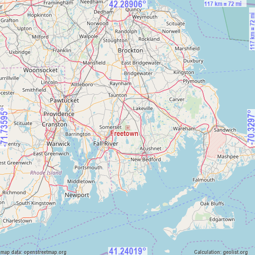
Freetown GPS coordinates[2]
41° 46' 0.372" North, 71° 1' 58.152" West
| Map corner | latitude | longitude |
|---|---|---|
| Upper-left | 42.28906°, | -71.73595° |
| Center: | 41.76677°, | -71.03282° |
| Lower-right: | 41.24019°, | -70.3297° |
| Map W x H: | 116.6×116.6 km | = 72.5×72.5mi |
| max Lat: | 71.29058° ⇑26.4% North |
| Freetown: | 41.76677° |
| min Lat: | ⇓73.6% South 19.06759° |
| min Long | Freetown | max Long |
| -171.73463° | -71.03282° | -66.98998° |
| W 97.6%⇐ | ⇒2.4% E |
Elevation
Elevation of Freetown is 29 m = 95 ft, and this is 265.8 m = 872 ft below average elevation for this country.
| Max E: |
3189 m = 10463 ft | 84.8% |
| Avg. | 294.8 m = 967 ft | |
| Freetown | 29 m = 95 ft | |
Min E: |
-60 m = -197 ft | 15.2% |
See also: United States elevation on elevation.city.
Geographical zone
Freetown is located in North temperate zone (between Tropic of Cancer and the Arctic Circle). Distance of this Northern Tropic circle is 2038.1 km =1266.4 mi to South.| Distance of | km | miles | from Freetown |
|---|---|---|---|
| North Pole | 5363 | 3332.4 | to North |
| Arctic Circle | 2757.1 | 1713.2 | to North |
| Tropic Cancer | 2038.1 | 1266.4 | to South |
| Equator | 4644 | 2885.6 | to South |


Nearby cities:
15 places around Freetown: (largest is in red/bold)
• Acushnet
14.1 km =8.8 mi,  132°
132°
• Acushnet Center
13.9 km =8.6 mi, 130°
• Assonet
4.4 km =2.7 mi,  318°
318°
• Berkley
9.7 km =6 mi,  334°
334°
• Dighton
9 km =5.6 mi,  305°
305°
• Fall River
12.5 km =7.8 mi,  234°
234°
• Head of Westport
16.4 km =10.2 mi,  188°
188°
• Middleborough Center
16.7 km =10.4 mi,  31°
31°
• North Lakeville
12.6 km =7.8 mi,  36°
36°
• North Westport
12.7 km =7.9 mi,  201°
201°
• Ocean Grove
15.2 km =9.4 mi,  254°
254°
• Smith Mills
14.6 km =9.1 mi,  166°
166°
• Somerset
8 km =5 mi,  272°
272°
• Swansea
13.2 km =8.2 mi,  260°
260°
• Taunton
15.6 km =9.7 mi,  342°
342°
Sources, notices
• [Note1] Compared only with cities in United States existing in our database
• [Src1] Map data: © OpenStreetMap contributors (CC-BY-SA)
• [Src2] Other city data from geonames.org with taken over terms of usage.
• [Src3] Geographical zone / Annual Mean Temperature by Robert A. Rohde @ Wikipedia
