Beverly Cove geodata
Beverly Cove (Massachusetts) is a populated place; located in United States in America/New_York (GMT-4) time zone. With population of 40,365 people, there are 1201 cities with bigger population in this country. Compared to other cities in United States, 80.2% of cities are located further ↓South; 97.9% of cities are located further ←West and 89.1% of cities have higher elevation than Beverly Cove. Note1


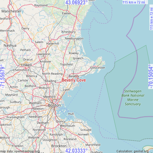
Beverly Cove GPS coordinates[2]
42° 33' 12.348" North, 70° 51' 13.176" West
| Map corner | latitude | longitude |
|---|---|---|
| Upper-left | 43.06923°, | -71.55679° |
| Center: | 42.55343°, | -70.85366° |
| Lower-right: | 42.03333°, | -70.15054° |
| Map W x H: | 115.2×115.2 km | = 71.6×71.6mi |
| max Lat: | 71.29058° ⇑19.8% North |
| Beverly Cove: | 42.55343° |
| min Lat: | ⇓80.2% South 19.06759° |
| min Long | Beverly Cove | max Long |
| -171.73463° | -70.85366° | -66.98998° |
| W 97.9%⇐ | ⇒2.1% E |
Elevation
Elevation of Beverly Cove is 18 m = 59 ft, and this is 276.8 m = 908 ft below average elevation for this country.
| Max E: |
3189 m = 10463 ft | 89.1% |
| Avg. | 294.8 m = 967 ft | |
| Beverly Cove | 18 m = 59 ft | |
Min E: |
-60 m = -197 ft | 10.9% |
See also: Beverly Cove elevation on elevation.city.
Geographical zone
Beverly Cove is located in North temperate zone (between Tropic of Cancer and the Arctic Circle). Distance of this Northern Tropic circle is 2125.6 km =1320.8 mi to South.| Distance of | km | miles | from Beverly Cove |
|---|---|---|---|
| North Pole | 5275.6 | 3278.1 | to North |
| Arctic Circle | 2669.7 | 1658.9 | to North |
| Tropic Cancer | 2125.6 | 1320.8 | to South |
| Equator | 4731.5 | 2940 | to South |


Nearby cities:
15 places around Beverly Cove: (largest is in red/bold)
• Beverly
2.2 km =1.4 mi,  284°
284°
• Danvers
6.7 km =4.2 mi,  291°
291°
• Essex
10.5 km =6.5 mi,  33°
33°
• Ipswich
14 km =8.7 mi,  4°
4°
• Lynn
12.4 km =7.7 mi,  219°
219°
• Manchester-by-the-Sea
7.5 km =4.7 mi,  68°
68°
• Marblehead
5.9 km =3.7 mi,  183°
183°
• Middleton
14.1 km =8.8 mi, 289°
• Nahant
15.1 km =9.4 mi,  200°
200°
• Peabody
6.8 km =4.2 mi,  245°
245°
• Salem
5.2 km =3.2 mi, 223°
• South Peabody
9.2 km =5.7 mi,  238°
238°
• Swampscott
10.6 km =6.6 mi,  209°
209°
• Topsfield
12.2 km =7.6 mi,  320°
320°
• Wenham
6.4 km =4 mi,  331°
331°
Sources, notices
• [Note1] Compared only with cities in United States existing in our database
• [Src1] Map data: © OpenStreetMap contributors (CC-BY-SA)
• [Src2] Other city data from geonames.org with taken over terms of usage.
• [Src3] Geographical zone / Annual Mean Temperature by Robert A. Rohde @ Wikipedia
