Beverly geodata
Beverly (Massachusetts) is a populated place; located in United States in America/New_York (GMT-4) time zone. With population of 41,186 people, there are 1165 cities with bigger population in this country. Compared to other cities in United States, 80.2% of cities are located further ↓South; 97.9% of cities are located further ←West and 91.5% of cities have higher elevation than Beverly. Note1


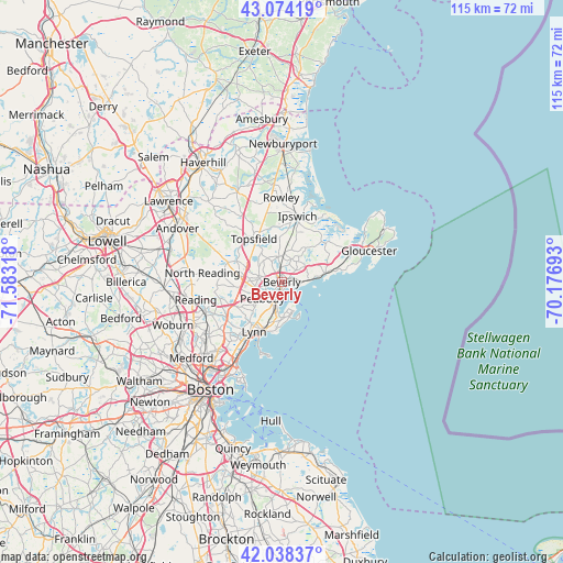
Beverly GPS coordinates[2]
42° 33' 30.348" North, 70° 52' 48.18" West
| Map corner | latitude | longitude |
|---|---|---|
| Upper-left | 43.07419°, | -71.58318° |
| Center: | 42.55843°, | -70.88005° |
| Lower-right: | 42.03837°, | -70.17693° |
| Map W x H: | 115.2×115.2 km | = 71.6×71.6mi |
| max Lat: | 71.29058° ⇑19.8% North |
| Beverly: | 42.55843° |
| min Lat: | ⇓80.2% South 19.06759° |
| min Long | Beverly | max Long |
| -171.73463° | -70.88005° | -66.98998° |
| W 97.9%⇐ | ⇒2.1% E |
Elevation
Elevation of Beverly is 13 m = 43 ft, and this is 281.8 m = 925 ft below average elevation for this country.
| Max E: |
3189 m = 10463 ft | 91.5% |
| Avg. | 294.8 m = 967 ft | |
| Beverly | 13 m = 43 ft | |
Min E: |
-60 m = -197 ft | 8.5% |
See also: Beverly elevation on elevation.city.
Geographical zone
Beverly is located in North temperate zone (between Tropic of Cancer and the Arctic Circle). Distance of this Northern Tropic circle is 2126.1 km =1321.1 mi to South.| Distance of | km | miles | from Beverly |
|---|---|---|---|
| North Pole | 5275 | 3277.7 | to North |
| Arctic Circle | 2669.1 | 1658.5 | to North |
| Tropic Cancer | 2126.1 | 1321.1 | to South |
| Equator | 4732.1 | 2940.4 | to South |


Nearby cities:
15 places around Beverly: (largest is in red/bold)
• Beverly Cove
2.2 km =1.4 mi,  104°
104°
• Danvers
4.5 km =2.8 mi,  294°
294°
• Essex
11.4 km =7.1 mi,  44°
44°
• Ipswich
13.8 km =8.6 mi,  13°
13°
• Lynn
11.7 km =7.3 mi,  209°
209°
• Lynnfield
13.9 km =8.6 mi,  261°
261°
• Manchester-by-the-Sea
9.4 km =5.8 mi,  76°
76°
• Marblehead
6.7 km =4.2 mi,  164°
164°
• Middleton
11.9 km =7.4 mi, 290°
• Peabody
5.2 km =3.2 mi,  229°
229°
• Salem
4.5 km =2.8 mi,  197°
197°
• South Peabody
7.8 km =4.8 mi, 226°
• Swampscott
10.2 km =6.3 mi, 197°
• Topsfield
10.5 km =6.5 mi,  327°
327°
• Wenham
5.2 km =3.2 mi,  349°
349°
Sources, notices
• [Note1] Compared only with cities in United States existing in our database
• [Src1] Map data: © OpenStreetMap contributors (CC-BY-SA)
• [Src2] Other city data from geonames.org with taken over terms of usage.
• [Src3] Geographical zone / Annual Mean Temperature by Robert A. Rohde @ Wikipedia
