Bay City geodata
Bay City (Michigan) is a seat of a second-order administrative division; located in United States in America/Detroit (GMT-4) time zone. With population of 33,917 people, there are 1456 cities with bigger population in this country. Compared to other cities in United States, 86.7% of cities are located further ↓South; 59.6% of cities are located further ←West and 55.3% of cities have higher elevation than Bay City. Note1


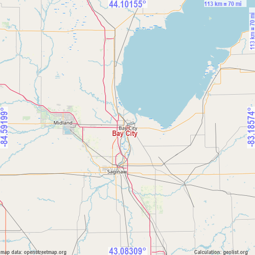
Bay City GPS coordinates[2]
43° 35' 40.092" North, 83° 53' 19.896" West
| Map corner | latitude | longitude |
|---|---|---|
| Upper-left | 44.10155°, | -84.59199° |
| Center: | 43.59447°, | -83.88886° |
| Lower-right: | 43.08309°, | -83.18574° |
| Map W x H: | 113.2×113.2 km | = 70.3×70.3mi |
| max Lat: | 71.29058° ⇑13.3% North |
| Bay City: | 43.59447° |
| min Lat: | ⇓86.7% South 19.06759° |
| min Long | Bay City | max Long |
| -171.73463° | -83.88886° | -66.98998° |
| W 59.6%⇐ | ⇒40.4% E |
Elevation
Elevation of Bay City is 179 m = 587 ft, and this is 115.8 m = 380 ft below average elevation for this country.
| Max E: |
3189 m = 10463 ft | 55.3% |
| Avg. | 294.8 m = 967 ft | |
| Bay City | 179 m = 587 ft | |
Min E: |
-60 m = -197 ft | 44.7% |
See also: United States elevation on elevation.city.
Geographical zone
Bay City is located in North temperate zone (between Tropic of Cancer and the Arctic Circle). Distance of this Northern Tropic circle is 2241.3 km =1392.7 mi to South.| Distance of | km | miles | from Bay City |
|---|---|---|---|
| North Pole | 5159.8 | 3206.2 | to North |
| Arctic Circle | 2553.9 | 1586.9 | to North |
| Tropic Cancer | 2241.3 | 1392.7 | to South |
| Equator | 4847.3 | 3012 | to South |


Nearby cities:
15 places around Bay City: (largest is in red/bold)
• Auburn
14.6 km =9.1 mi,  273°
273°
• Bridgeport
26.1 km =16.2 mi,  178°
178°
• Buena Vista
19.4 km =12.1 mi, 182°
• Carrollton
15.5 km =9.6 mi,  192°
192°
• Essexville
4.4 km =2.7 mi,  58°
58°
• Fairgrove
28.9 km =18 mi,  105°
105°
• Freeland
20.4 km =12.7 mi,  247°
247°
• Midland
28.9 km =18 mi, 274°
• Pinconning
29.5 km =18.3 mi,  348°
348°
• Reese
22.3 km =13.9 mi,  135°
135°
• Robin Glen-Indiantown
15.3 km =9.5 mi,  164°
164°
• Saginaw
20.1 km =12.5 mi, 194°
• Saginaw Township North
17.7 km =11 mi,  212°
212°
• Shields
24.1 km =15 mi, 214°
• Zilwaukee
13.4 km =8.3 mi, 191°
Sources, notices
• [Note1] Compared only with cities in United States existing in our database
• [Src1] Map data: © OpenStreetMap contributors (CC-BY-SA)
• [Src2] Other city data from geonames.org with taken over terms of usage.
• [Src3] Geographical zone / Annual Mean Temperature by Robert A. Rohde @ Wikipedia
