Midland geodata
Midland (Michigan) is a seat of a second-order administrative division; located in United States in America/Detroit (GMT-4) time zone. With population of 42,200 people, there are 1133 cities with bigger population in this country. Compared to other cities in United States, 86.8% of cities are located further ↓South; 58.5% of cities are located further ←West and 51.4% of cities have higher elevation than Midland. Note1


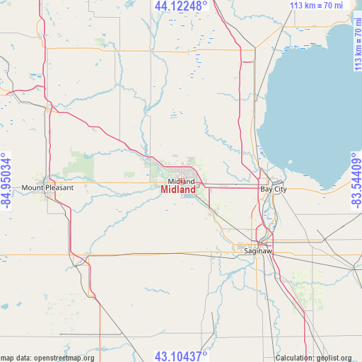
Midland GPS coordinates[2]
43° 36' 56.088" North, 84° 14' 49.956" West
| Map corner | latitude | longitude |
|---|---|---|
| Upper-left | 44.12248°, | -84.95034° |
| Center: | 43.61558°, | -84.24721° |
| Lower-right: | 43.10437°, | -83.54409° |
| Map W x H: | 113.2×113.2 km | = 70.3×70.3mi |
| max Lat: | 71.29058° ⇑13.2% North |
| Midland: | 43.61558° |
| min Lat: | ⇓86.8% South 19.06759° |
| min Long | Midland | max Long |
| -171.73463° | -84.24721° | -66.98998° |
| W 58.5%⇐ | ⇒41.5% E |
Elevation
Elevation of Midland is 193 m = 633 ft, and this is 101.8 m = 334 ft below average elevation for this country.
| Max E: |
3189 m = 10463 ft | 51.4% |
| Avg. | 294.8 m = 967 ft | |
| Midland | 193 m = 633 ft | |
Min E: |
-60 m = -197 ft | 48.6% |
See also: Midland elevation on elevation.city.
Geographical zone
Midland is located in North temperate zone (between Tropic of Cancer and the Arctic Circle). Distance of this Northern Tropic circle is 2243.7 km =1394.2 mi to South.| Distance of | km | miles | from Midland |
|---|---|---|---|
| North Pole | 5157.5 | 3204.7 | to North |
| Arctic Circle | 2551.6 | 1585.5 | to North |
| Tropic Cancer | 2243.7 | 1394.2 | to South |
| Equator | 4849.6 | 3013.4 | to South |


Nearby cities:
15 places around Midland: (largest is in red/bold)
• Auburn
14.4 km =8.9 mi,  95°
95°
• Bay City
28.9 km =18 mi,  94°
94°
• Breckenridge
29.5 km =18.3 mi,  218°
218°
• Carrollton
30.9 km =19.2 mi,  124°
124°
• Coleman
31.4 km =19.5 mi,  299°
299°
• Essexville
32.6 km =20.3 mi, 90°
• Freeland
14.2 km =8.8 mi,  135°
135°
• Hemlock
22.4 km =13.9 mi,  176°
176°
• Merrill
23.8 km =14.8 mi,  196°
196°
• Pinconning
34.9 km =21.7 mi,  40°
40°
• Saginaw
32.4 km =20.1 mi,  132°
132°
• Saginaw Township North
26 km =16.2 mi, 131°
• Sanford
12.5 km =7.8 mi, 300°
• Shields
27.1 km =16.8 mi,  145°
145°
• Zilwaukee
30.5 km =19 mi, 120°
Sources, notices
• [Note1] Compared only with cities in United States existing in our database
• [Src1] Map data: © OpenStreetMap contributors (CC-BY-SA)
• [Src2] Other city data from geonames.org with taken over terms of usage.
• [Src3] Geographical zone / Annual Mean Temperature by Robert A. Rohde @ Wikipedia
