Manistee geodata
Manistee (Michigan) is a seat of a second-order administrative division; located in United States in America/Detroit (GMT-4) time zone. With population of 6,084 people, there are 6347 cities with bigger population in this country. Compared to other cities in United States, 89.4% of cities are located further ↓South; 52% of cities are located further ←West and 51.9% of cities have lower elevation than Manistee. Note1


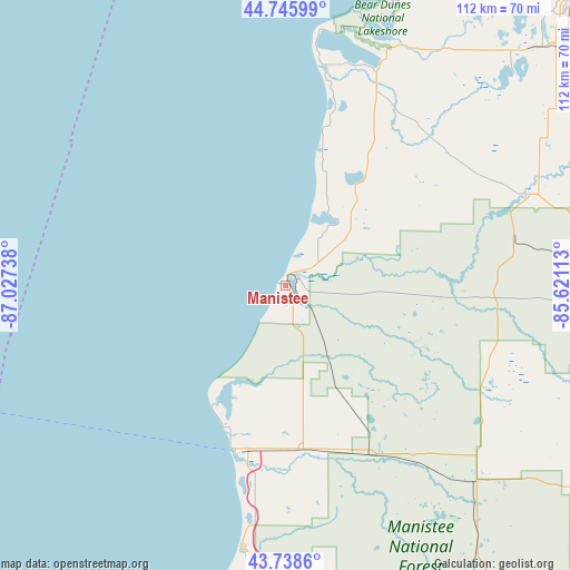
Manistee GPS coordinates[2]
44° 14' 40.02" North, 86° 19' 27.3" West
| Map corner | latitude | longitude |
|---|---|---|
| Upper-left | 44.74599°, | -87.02738° |
| Center: | 44.24445°, | -86.32425° |
| Lower-right: | 43.7386°, | -85.62113° |
| Map W x H: | 112×112 km | = 69.6×69.6mi |
| max Lat: | 71.29058° ⇑10.6% North |
| Manistee: | 44.24445° |
| min Lat: | ⇓89.4% South 19.06759° |
| min Long | Manistee | max Long |
| -171.73463° | -86.32425° | -66.98998° |
| W 52%⇐ | ⇒48% E |
Elevation
Elevation of Manistee is 206 m = 676 ft, and this is 88.8 m = 291 ft below average elevation for this country.
| Max E: |
3189 m = 10463 ft | 48.1% |
| Avg. | 294.8 m = 967 ft | |
| Manistee | 206 m = 676 ft | |
Min E: |
-60 m = -197 ft | 51.9% |
See also: United States elevation on elevation.city.
Geographical zone
Manistee is located in North temperate zone (between Tropic of Cancer and the Arctic Circle). Distance of this Northern Tropic circle is 2313.6 km =1437.6 mi to South.| Distance of | km | miles | from Manistee |
|---|---|---|---|
| North Pole | 5087.5 | 3161.2 | to North |
| Arctic Circle | 2481.7 | 1542.1 | to North |
| Tropic Cancer | 2313.6 | 1437.6 | to South |
| Equator | 4919.5 | 3056.8 | to South |


Nearby cities:
15 places around Manistee: (largest is in red/bold)
• Baldwin
53.7 km =33.4 mi,  135°
135°
• Beulah
46.9 km =29.1 mi,  23°
23°
• Buckley
59 km =36.7 mi,  60°
60°
• Chums Corner
71.2 km =44.2 mi,  48°
48°
• Frankfort
43.9 km =27.3 mi,  9°
9°
• Grawn
68.3 km =42.4 mi, 47°
• Hart
60.8 km =37.8 mi,  182°
182°
• Interlochen
62.7 km =39 mi,  44°
44°
• Kingsley
73.2 km =45.5 mi, 58°
• Ludington
33.7 km =20.9 mi,  197°
197°
• Oak Hill
2.7 km =1.7 mi, 144°
• Parkdale
3.1 km =1.9 mi,  33°
33°
• Pentwater
52.2 km =32.4 mi,  189°
189°
• Scottville
32.4 km =20.1 mi,  173°
173°
• Shelby
70.8 km =44 mi, 182°
Sources, notices
• [Note1] Compared only with cities in United States existing in our database
• [Src1] Map data: © OpenStreetMap contributors (CC-BY-SA)
• [Src2] Other city data from geonames.org with taken over terms of usage.
• [Src3] Geographical zone / Annual Mean Temperature by Robert A. Rohde @ Wikipedia
