Blissfield geodata
Blissfield (Michigan) is a populated place; located in United States in America/Detroit (GMT-4) time zone. With population of 3,255 people, there are 9217 cities with bigger population in this country. Compared to other cities in United States, 74.2% of cities are located further ↓South; 59.7% of cities are located further ←West and 53% of cities have lower elevation than Blissfield. Note1
Administrative division(s):
- Level 1: Michigan
- Level 2: Lenawee County
- Level 3: Township of Blissfield


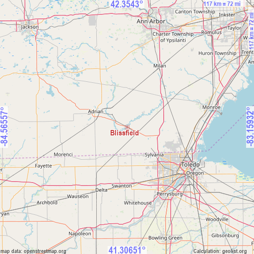
Blissfield GPS coordinates[2]
41° 49' 57.18" North, 83° 51' 44.784" West
| Map corner | latitude | longitude |
|---|---|---|
| Upper-left | 42.3543°, | -84.56557° |
| Center: | 41.83255°, | -83.86244° |
| Lower-right: | 41.30651°, | -83.15932° |
| Map W x H: | 116.5×116.5 km | = 72.4×72.4mi |
| max Lat: | 71.29058° ⇑25.8% North |
| Blissfield: | 41.83255° |
| min Lat: | ⇓74.2% South 19.06759° |
| min Long | Blissfield | max Long |
| -171.73463° | -83.86244° | -66.98998° |
| W 59.7%⇐ | ⇒40.3% E |
Elevation
Elevation of Blissfield is 210 m = 689 ft, and this is 84.8 m = 278 ft below average elevation for this country.
| Max E: |
3189 m = 10463 ft | 47% |
| Avg. | 294.8 m = 967 ft | |
| Blissfield | 210 m = 689 ft | |
Min E: |
-60 m = -197 ft | 53% |
See also: United States elevation on elevation.city.
Geographical zone
Blissfield is located in North temperate zone (between Tropic of Cancer and the Arctic Circle). Distance of this Northern Tropic circle is 2045.4 km =1271 mi to South.| Distance of | km | miles | from Blissfield |
|---|---|---|---|
| North Pole | 5355.7 | 3327.9 | to North |
| Arctic Circle | 2749.8 | 1708.6 | to North |
| Tropic Cancer | 2045.4 | 1271 | to South |
| Equator | 4651.3 | 2890.2 | to South |


Nearby cities:
15 places around Blissfield: (largest is in red/bold)
• Adrian
16.2 km =10.1 mi,  296°
296°
• Britton
17.3 km =10.7 mi,  8°
8°
• Clinton
28.1 km =17.5 mi,  341°
341°
• Deerfield
9.3 km =5.8 mi,  47°
47°
• Dundee
21.8 km =13.5 mi, 50°
• Holland
26.6 km =16.5 mi,  151°
151°
• Lambertville
20.8 km =12.9 mi,  110°
110°
• Lyons
22.7 km =14.1 mi,  229°
229°
• Metamora
14 km =8.7 mi,  196°
196°
• Ottawa Hills
26.1 km =16.2 mi,  135°
135°
• Petersburg
14.4 km =8.9 mi,  58°
58°
• Swanton
27.2 km =16.9 mi,  185°
185°
• Sylvania
17.7 km =11 mi, 135°
• Tecumseh
20.2 km =12.6 mi, 340°
• Temperance
25 km =15.5 mi,  103°
103°
Sources, notices
• [Note1] Compared only with cities in United States existing in our database
• [Src1] Map data: © OpenStreetMap contributors (CC-BY-SA)
• [Src2] Other city data from geonames.org with taken over terms of usage.
• [Src3] Geographical zone / Annual Mean Temperature by Robert A. Rohde @ Wikipedia
