Union City geodata
Union City (Michigan) is a populated place; located in United States in America/Detroit (GMT-4) time zone. With population of 1,584 people, there are 13344 cities with bigger population in this country. Compared to other cities in United States, 76.2% of cities are located further ↓South; 55.6% of cities are located further ←West and 68.9% of cities have lower elevation than Union City. Note1


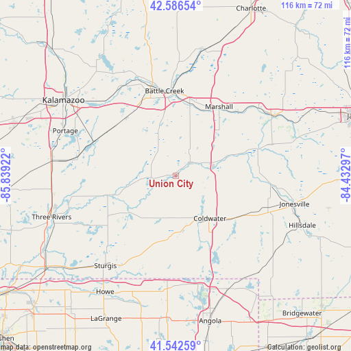
Union City GPS coordinates[2]
42° 4' 0.156" North, 85° 8' 9.924" West
| Map corner | latitude | longitude |
|---|---|---|
| Upper-left | 42.58654°, | -85.83922° |
| Center: | 42.06671°, | -85.13609° |
| Lower-right: | 41.54259°, | -84.43297° |
| Map W x H: | 116.1×116.1 km | = 72.1×72.1mi |
| max Lat: | 71.29058° ⇑23.8% North |
| Union City: | 42.06671° |
| min Lat: | ⇓76.2% South 19.06759° |
| min Long | Union City | max Long |
| -171.73463° | -85.13609° | -66.98998° |
| W 55.6%⇐ | ⇒44.4% E |
Elevation
Elevation of Union City is 280 m = 919 ft, and this is 14.8 m = 49 ft below average elevation for this country.
| Max E: |
3189 m = 10463 ft | 31.1% |
| Avg. | 294.8 m = 967 ft | |
| Union City | 280 m = 919 ft | |
Min E: |
-60 m = -197 ft | 68.9% |
See also: United States elevation on elevation.city.
Geographical zone
Union City is located in North temperate zone (between Tropic of Cancer and the Arctic Circle). Distance of this Northern Tropic circle is 2071.5 km =1287.2 mi to South.| Distance of | km | miles | from Union City |
|---|---|---|---|
| North Pole | 5329.7 | 3311.7 | to North |
| Arctic Circle | 2723.8 | 1692.5 | to North |
| Tropic Cancer | 2071.5 | 1287.2 | to South |
| Equator | 4677.4 | 2906.4 | to South |


Nearby cities:
15 places around Union City: (largest is in red/bold)
• Athens
8.5 km =5.3 mi,  286°
286°
• Battle Creek
28.1 km =17.5 mi,  352°
352°
• Bronson
22.2 km =13.8 mi,  192°
192°
• Brownlee Park
28 km =17.4 mi,  358°
358°
• Burr Oak
28.7 km =17.8 mi,  211°
211°
• Climax
25.2 km =15.7 mi,  319°
319°
• Coldwater
18 km =11.2 mi,  141°
141°
• Colon
19.7 km =12.2 mi,  232°
232°
• Homer
28.4 km =17.6 mi,  71°
71°
• Lakeview
26.5 km =16.5 mi, 346°
• Marshall
26.9 km =16.7 mi,  31°
31°
• Mendon
26.8 km =16.7 mi,  255°
255°
• Quincy
24.9 km =15.5 mi,  123°
123°
• Springfield
30.1 km =18.7 mi,  343°
343°
• Tekonsha
12.8 km =8 mi,  76°
76°
Sources, notices
• [Note1] Compared only with cities in United States existing in our database
• [Src1] Map data: © OpenStreetMap contributors (CC-BY-SA)
• [Src2] Other city data from geonames.org with taken over terms of usage.
• [Src3] Geographical zone / Annual Mean Temperature by Robert A. Rohde @ Wikipedia
