Coleman geodata
Coleman (Michigan) is a populated place; located in United States in America/Detroit (GMT-4) time zone. With population of 1,205 people, there are 15100 cities with bigger population in this country. Compared to other cities in United States, 87.4% of cities are located further ↓South; 57% of cities are located further ←West and 58.4% of cities have lower elevation than Coleman. Note1


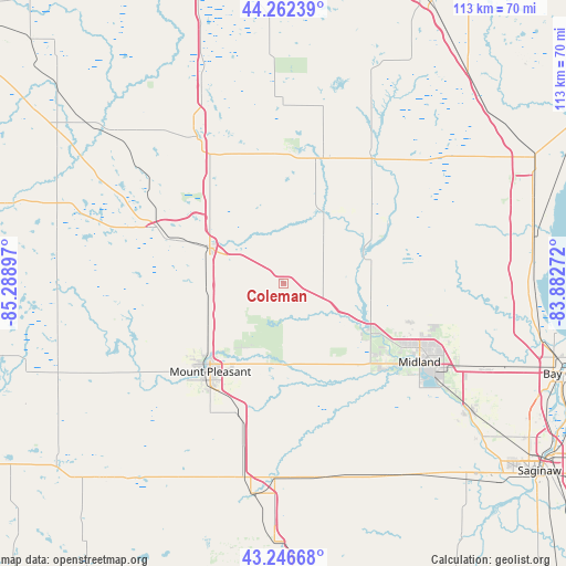
Coleman GPS coordinates[2]
43° 45' 24.084" North, 84° 35' 9.024" West
| Map corner | latitude | longitude |
|---|---|---|
| Upper-left | 44.26239°, | -85.28897° |
| Center: | 43.75669°, | -84.58584° |
| Lower-right: | 43.24668°, | -83.88272° |
| Map W x H: | 112.9×112.9 km | = 70.2×70.2mi |
| max Lat: | 71.29058° ⇑12.6% North |
| Coleman: | 43.75669° |
| min Lat: | ⇓87.4% South 19.06759° |
| min Long | Coleman | max Long |
| -171.73463° | -84.58584° | -66.98998° |
| W 57%⇐ | ⇒43% E |
Elevation
Elevation of Coleman is 232 m = 761 ft, and this is 62.8 m = 206 ft below average elevation for this country.
| Max E: |
3189 m = 10463 ft | 41.6% |
| Avg. | 294.8 m = 967 ft | |
| Coleman | 232 m = 761 ft | |
Min E: |
-60 m = -197 ft | 58.4% |
See also: United States elevation on elevation.city.
Geographical zone
Coleman is located in North temperate zone (between Tropic of Cancer and the Arctic Circle). Distance of this Northern Tropic circle is 2259.4 km =1403.9 mi to South.| Distance of | km | miles | from Coleman |
|---|---|---|---|
| North Pole | 5141.8 | 3195 | to North |
| Arctic Circle | 2535.9 | 1575.7 | to North |
| Tropic Cancer | 2259.4 | 1403.9 | to South |
| Equator | 4865.3 | 3023.2 | to South |


Nearby cities:
15 places around Coleman: (largest is in red/bold)
• Alma
42.4 km =26.3 mi,  188°
188°
• Beaverton
16.1 km =10 mi,  30°
30°
• Breckenridge
39.8 km =24.7 mi,  167°
167°
• Clare
16.2 km =10.1 mi,  295°
295°
• Farwell
24.2 km =15 mi,  291°
291°
• Gladwin
26.2 km =16.3 mi,  17°
17°
• Harrison
33.8 km =21 mi,  329°
329°
• Lake Isabella
35.4 km =22 mi,  249°
249°
• Merrill
43.8 km =27.2 mi,  151°
151°
• Midland
31.4 km =19.5 mi,  119°
119°
• Mount Pleasant
22.9 km =14.2 mi,  219°
219°
• Saint Louis
38.8 km =24.1 mi,  182°
182°
• Sanford
19 km =11.8 mi, 119°
• Shepherd
27.3 km =17 mi,  198°
198°
• Weidman
31.7 km =19.7 mi,  255°
255°
Sources, notices
• [Note1] Compared only with cities in United States existing in our database
• [Src1] Map data: © OpenStreetMap contributors (CC-BY-SA)
• [Src2] Other city data from geonames.org with taken over terms of usage.
• [Src3] Geographical zone / Annual Mean Temperature by Robert A. Rohde @ Wikipedia
