Breckenridge geodata
Breckenridge (Michigan) is a populated place; located in United States in America/Detroit (GMT-4) time zone. With population of 1,305 people, there are 14570 cities with bigger population in this country. Compared to other cities in United States, 85.9% of cities are located further ↓South; 57.5% of cities are located further ←West and 56.9% of cities have lower elevation than Breckenridge. Note1


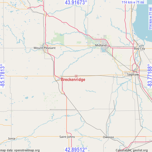
Breckenridge GPS coordinates[2]
43° 24' 29.088" North, 84° 28' 30" West
| Map corner | latitude | longitude |
|---|---|---|
| Upper-left | 43.91673°, | -85.17813° |
| Center: | 43.40808°, | -84.475° |
| Lower-right: | 42.89512°, | -83.77188° |
| Map W x H: | 113.6×113.6 km | = 70.6×70.6mi |
| max Lat: | 71.29058° ⇑14.1% North |
| Breckenridge: | 43.40808° |
| min Lat: | ⇓85.9% South 19.06759° |
| min Long | Breckenridge | max Long |
| -171.73463° | -84.475° | -66.98998° |
| W 57.5%⇐ | ⇒42.5% E |
Elevation
Elevation of Breckenridge is 226 m = 741 ft, and this is 68.8 m = 226 ft below average elevation for this country.
| Max E: |
3189 m = 10463 ft | 43.1% |
| Avg. | 294.8 m = 967 ft | |
| Breckenridge | 226 m = 741 ft | |
Min E: |
-60 m = -197 ft | 56.9% |
See also: United States elevation on elevation.city.
Geographical zone
Breckenridge is located in North temperate zone (between Tropic of Cancer and the Arctic Circle). Distance of this Northern Tropic circle is 2220.6 km =1379.8 mi to South.| Distance of | km | miles | from Breckenridge |
|---|---|---|---|
| North Pole | 5180.5 | 3219 | to North |
| Arctic Circle | 2574.6 | 1599.8 | to North |
| Tropic Cancer | 2220.6 | 1379.8 | to South |
| Equator | 4826.5 | 2999 | to South |


Nearby cities:
15 places around Breckenridge: (largest is in red/bold)
• Alma
15.3 km =9.5 mi,  257°
257°
• Ashley
24.6 km =15.3 mi,  179°
179°
• Elsie
36.2 km =22.5 mi,  168°
168°
• Freeland
31.3 km =19.4 mi,  65°
65°
• Hemlock
19.8 km =12.3 mi,  87°
87°
• Ithaca
16.8 km =10.4 mi,  219°
219°
• Maple Rapids
38 km =23.6 mi,  207°
207°
• Merrill
11.8 km =7.3 mi, 89°
• Midland
29.5 km =18.3 mi,  38°
38°
• Mount Pleasant
31.6 km =19.6 mi,  311°
311°
• Saint Charles
29.7 km =18.5 mi,  114°
114°
• Saint Louis
10.6 km =6.6 mi,  270°
270°
• Sanford
30.4 km =18.9 mi,  14°
14°
• Shepherd
22 km =13.7 mi, 306°
• Shields
33.8 km =21 mi, 88°
Sources, notices
• [Note1] Compared only with cities in United States existing in our database
• [Src1] Map data: © OpenStreetMap contributors (CC-BY-SA)
• [Src2] Other city data from geonames.org with taken over terms of usage.
• [Src3] Geographical zone / Annual Mean Temperature by Robert A. Rohde @ Wikipedia
