Sanford geodata
Sanford (Michigan) is a populated place; located in United States in America/Detroit (GMT-4) time zone. With population of 849 people, there are 17372 cities with bigger population in this country. Compared to other cities in United States, 87.1% of cities are located further ↓South; 57.9% of cities are located further ←West and 51.4% of cities have higher elevation than Sanford. Note1


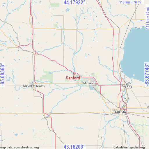
Sanford GPS coordinates[2]
43° 40' 22.116" North, 84° 22' 49.98" West
| Map corner | latitude | longitude |
|---|---|---|
| Upper-left | 44.17922°, | -85.08368° |
| Center: | 43.67281°, | -84.38055° |
| Lower-right: | 43.16209°, | -83.67743° |
| Map W x H: | 113.1×113.1 km | = 70.3×70.3mi |
| max Lat: | 71.29058° ⇑12.9% North |
| Sanford: | 43.67281° |
| min Lat: | ⇓87.1% South 19.06759° |
| min Long | Sanford | max Long |
| -171.73463° | -84.38055° | -66.98998° |
| W 57.9%⇐ | ⇒42.1% E |
Elevation
Elevation of Sanford is 193 m = 633 ft, and this is 101.8 m = 334 ft below average elevation for this country.
| Max E: |
3189 m = 10463 ft | 51.4% |
| Avg. | 294.8 m = 967 ft | |
| Sanford | 193 m = 633 ft | |
Min E: |
-60 m = -197 ft | 48.6% |
See also: United States elevation on elevation.city.
Geographical zone
Sanford is located in North temperate zone (between Tropic of Cancer and the Arctic Circle). Distance of this Northern Tropic circle is 2250 km =1398.1 mi to South.| Distance of | km | miles | from Sanford |
|---|---|---|---|
| North Pole | 5151.1 | 3200.7 | to North |
| Arctic Circle | 2545.2 | 1581.5 | to North |
| Tropic Cancer | 2250 | 1398.1 | to South |
| Equator | 4856 | 3017.4 | to South |


Nearby cities:
15 places around Sanford: (largest is in red/bold)
• Auburn
26.2 km =16.3 mi,  107°
107°
• Beaverton
24.7 km =15.3 mi,  340°
340°
• Breckenridge
30.4 km =18.9 mi,  194°
194°
• Clare
35.2 km =21.9 mi,  297°
297°
• Coleman
19 km =11.8 mi, 299°
• Freeland
26.5 km =16.5 mi,  128°
128°
• Gladwin
35.3 km =21.9 mi,  346°
346°
• Hemlock
31.1 km =19.3 mi,  157°
157°
• Merrill
29.5 km =18.3 mi,  171°
171°
• Midland
12.5 km =7.8 mi,  120°
120°
• Mount Pleasant
32.2 km =20 mi,  255°
255°
• Saginaw Township North
38.3 km =23.8 mi, 128°
• Saint Louis
34.6 km =21.5 mi,  211°
211°
• Shepherd
30.2 km =18.8 mi,  236°
236°
• Shields
38.8 km =24.1 mi,  137°
137°
Sources, notices
• [Note1] Compared only with cities in United States existing in our database
• [Src1] Map data: © OpenStreetMap contributors (CC-BY-SA)
• [Src2] Other city data from geonames.org with taken over terms of usage.
• [Src3] Geographical zone / Annual Mean Temperature by Robert A. Rohde @ Wikipedia
