Marcellus geodata
Marcellus (Michigan) is a populated place; located in United States in America/Detroit (GMT-4) time zone. With population of 1,157 people, there are 15345 cities with bigger population in this country. Compared to other cities in United States, 75.9% of cities are located further ↓South; 53.4% of cities are located further ←West and 67.8% of cities have lower elevation than Marcellus. Note1


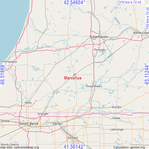
Marcellus GPS coordinates[2]
42° 1' 33.168" North, 85° 48' 56.016" West
| Map corner | latitude | longitude |
|---|---|---|
| Upper-left | 42.54604°, | -86.51869° |
| Center: | 42.02588°, | -85.81556° |
| Lower-right: | 41.50142°, | -85.11244° |
| Map W x H: | 116.2×116.1 km | = 72.2×72.1mi |
| max Lat: | 71.29058° ⇑24.1% North |
| Marcellus: | 42.02588° |
| min Lat: | ⇓75.9% South 19.06759° |
| min Long | Marcellus | max Long |
| -171.73463° | -85.81556° | -66.98998° |
| W 53.4%⇐ | ⇒46.6% E |
Elevation
Elevation of Marcellus is 275 m = 902 ft, and this is 19.8 m = 65 ft below average elevation for this country.
| Max E: |
3189 m = 10463 ft | 32.2% |
| Avg. | 294.8 m = 967 ft | |
| Marcellus | 275 m = 902 ft | |
Min E: |
-60 m = -197 ft | 67.8% |
See also: United States elevation on elevation.city.
Geographical zone
Marcellus is located in North temperate zone (between Tropic of Cancer and the Arctic Circle). Distance of this Northern Tropic circle is 2066.9 km =1284.3 mi to South.| Distance of | km | miles | from Marcellus |
|---|---|---|---|
| North Pole | 5334.2 | 3314.5 | to North |
| Arctic Circle | 2728.3 | 1695.3 | to North |
| Tropic Cancer | 2066.9 | 1284.3 | to South |
| Equator | 4672.8 | 2903.5 | to South |


Nearby cities:
15 places around Marcellus: (largest is in red/bold)
• Cassopolis
20.5 km =12.7 mi,  231°
231°
• Centreville
26.3 km =16.3 mi,  115°
115°
• Constantine
23.9 km =14.9 mi,  149°
149°
• Decatur
16 km =9.9 mi,  304°
304°
• Dowagiac
24.7 km =15.3 mi,  259°
259°
• Lawrence
29 km =18 mi,  317°
317°
• Lawton
15.9 km =9.9 mi,  350°
350°
• Mattawan
20.6 km =12.8 mi,  7°
7°
• Mendon
30.3 km =18.8 mi,  94°
94°
• Paw Paw
22.2 km =13.8 mi,  343°
343°
• Portage
27.5 km =17.1 mi,  44°
44°
• Schoolcraft
17.7 km =11 mi,  56°
56°
• Three Rivers
17.7 km =11 mi, 121°
• Vicksburg
25.6 km =15.9 mi,  65°
65°
• White Pigeon
29.1 km =18.1 mi, 150°
Sources, notices
• [Note1] Compared only with cities in United States existing in our database
• [Src1] Map data: © OpenStreetMap contributors (CC-BY-SA)
• [Src2] Other city data from geonames.org with taken over terms of usage.
• [Src3] Geographical zone / Annual Mean Temperature by Robert A. Rohde @ Wikipedia
