Dansville geodata
Dansville (Michigan) is a populated place; located in United States in America/Detroit (GMT-4) time zone. With population of 556 people, there are 20205 cities with bigger population in this country. Compared to other cities in United States, 80.2% of cities are located further ↓South; 58.3% of cities are located further ←West and 72.2% of cities have lower elevation than Dansville. Note1


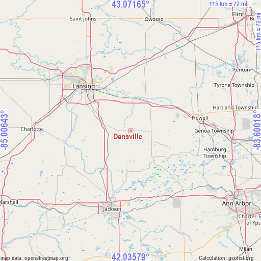
Dansville GPS coordinates[2]
42° 33' 21.132" North, 84° 18' 11.88" West
| Map corner | latitude | longitude |
|---|---|---|
| Upper-left | 43.07165°, | -85.00643° |
| Center: | 42.55587°, | -84.3033° |
| Lower-right: | 42.03579°, | -83.60018° |
| Map W x H: | 115.2×115.2 km | = 71.6×71.6mi |
| max Lat: | 71.29058° ⇑19.8% North |
| Dansville: | 42.55587° |
| min Lat: | ⇓80.2% South 19.06759° |
| min Long | Dansville | max Long |
| -171.73463° | -84.3033° | -66.98998° |
| W 58.3%⇐ | ⇒41.7% E |
Elevation
Elevation of Dansville is 297 m = 974 ft, and this is 2.2 m = 7 ft above average elevation for this country.
| Max E: |
3189 m = 10463 ft | 27.8% |
| Dansville | 297 m 974 ft | |
| Avg. | 294.8 m = 967 ft | |
Min E: |
-60 m = -197 ft | 72.2% |
See also: United States elevation on elevation.city.
Geographical zone
Dansville is located in North temperate zone (between Tropic of Cancer and the Arctic Circle). Distance of this Northern Tropic circle is 2125.9 km =1321 mi to South.| Distance of | km | miles | from Dansville |
|---|---|---|---|
| North Pole | 5275.3 | 3277.9 | to North |
| Arctic Circle | 2669.4 | 1658.7 | to North |
| Tropic Cancer | 2125.9 | 1321 | to South |
| Equator | 4731.8 | 2940.2 | to South |


Nearby cities:
15 places around Dansville: (largest is in red/bold)
• Dimondale
30 km =18.6 mi,  289°
289°
• East Lansing
25 km =15.5 mi,  323°
323°
• Eaton Rapids
29.3 km =18.2 mi,  259°
259°
• Fowlerville
22.2 km =13.8 mi,  58°
58°
• Haslett
22.7 km =14.1 mi,  339°
339°
• Holt
19.7 km =12.2 mi,  298°
298°
• Howell
31.1 km =19.3 mi,  79°
79°
• Lansing
28.5 km =17.7 mi,  313°
313°
• Leslie
15.7 km =9.8 mi,  222°
222°
• Mason
11.8 km =7.3 mi,  282°
282°
• Okemos
21.1 km =13.1 mi,  331°
331°
• Perry
30.9 km =19.2 mi,  12°
12°
• Stockbridge
15.4 km =9.6 mi,  139°
139°
• Webberville
16.3 km =10.1 mi,  40°
40°
• Williamston
14.9 km =9.3 mi, 6°
Sources, notices
• [Note1] Compared only with cities in United States existing in our database
• [Src1] Map data: © OpenStreetMap contributors (CC-BY-SA)
• [Src2] Other city data from geonames.org with taken over terms of usage.
• [Src3] Geographical zone / Annual Mean Temperature by Robert A. Rohde @ Wikipedia
