Fowlerville geodata
Fowlerville (Michigan) is a populated place; located in United States in America/Detroit (GMT-4) time zone. With population of 2,895 people, there are 9812 cities with bigger population in this country. Compared to other cities in United States, 81% of cities are located further ↓South; 59.1% of cities are located further ←West and 68.2% of cities have lower elevation than Fowlerville. Note1


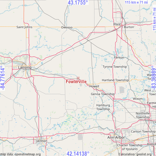
Fowlerville GPS coordinates[2]
42° 39' 38.124" North, 84° 4' 22.836" West
| Map corner | latitude | longitude |
|---|---|---|
| Upper-left | 43.1755°, | -84.77614° |
| Center: | 42.66059°, | -84.07301° |
| Lower-right: | 42.14138°, | -83.36989° |
| Map W x H: | 115×115 km | = 71.5×71.5mi |
| max Lat: | 71.29058° ⇑19% North |
| Fowlerville: | 42.66059° |
| min Lat: | ⇓81% South 19.06759° |
| min Long | Fowlerville | max Long |
| -171.73463° | -84.07301° | -66.98998° |
| W 59.1%⇐ | ⇒40.9% E |
Elevation
Elevation of Fowlerville is 277 m = 909 ft, and this is 17.8 m = 58 ft below average elevation for this country.
| Max E: |
3189 m = 10463 ft | 31.8% |
| Avg. | 294.8 m = 967 ft | |
| Fowlerville | 277 m = 909 ft | |
Min E: |
-60 m = -197 ft | 68.2% |
See also: United States elevation on elevation.city.
Geographical zone
Fowlerville is located in North temperate zone (between Tropic of Cancer and the Arctic Circle). Distance of this Northern Tropic circle is 2137.5 km =1328.2 mi to South.| Distance of | km | miles | from Fowlerville |
|---|---|---|---|
| North Pole | 5263.6 | 3270.6 | to North |
| Arctic Circle | 2657.8 | 1651.5 | to North |
| Tropic Cancer | 2137.5 | 1328.2 | to South |
| Equator | 4743.4 | 2947.4 | to South |


Nearby cities:
15 places around Fowlerville: (largest is in red/bold)
• Argentine
23.5 km =14.6 mi,  51°
51°
• Bancroft
24.3 km =15.1 mi,  1°
1°
• Brighton
28.1 km =17.5 mi,  121°
121°
• Byron
20.9 km =13 mi,  30°
30°
• Dansville
22.2 km =13.8 mi,  238°
238°
• Durand
28.9 km =18 mi,  14°
14°
• Haslett
28.5 km =17.7 mi,  289°
289°
• Howell
13.2 km =8.2 mi, 116°
• Linden
29.3 km =18.2 mi, 54°
• Morrice
21.6 km =13.4 mi,  336°
336°
• Perry
22 km =13.7 mi,  327°
327°
• Pinckney
24.8 km =15.4 mi,  155°
155°
• Stockbridge
24.9 km =15.5 mi,  200°
200°
• Webberville
8.3 km =5.2 mi,  274°
274°
• Williamston
17.5 km =10.9 mi,  280°
280°
Sources, notices
• [Note1] Compared only with cities in United States existing in our database
• [Src1] Map data: © OpenStreetMap contributors (CC-BY-SA)
• [Src2] Other city data from geonames.org with taken over terms of usage.
• [Src3] Geographical zone / Annual Mean Temperature by Robert A. Rohde @ Wikipedia
