Pinckney geodata
Pinckney (Michigan) is a populated place; located in United States in America/Detroit (GMT-4) time zone. With population of 2,436 people, there are 10772 cities with bigger population in this country. Compared to other cities in United States, 79.4% of cities are located further ↓South; 59.4% of cities are located further ←West and 67.8% of cities have lower elevation than Pinckney. Note1
Administrative division(s):
- Level 1: Michigan
- Level 2: Livingston County
- Level 3: Township of Putnam


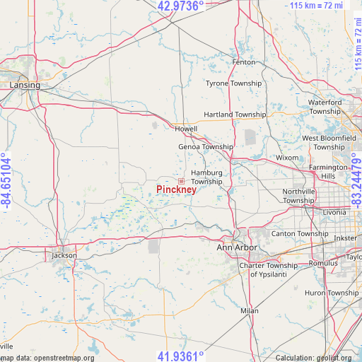
Pinckney GPS coordinates[2]
42° 27' 25.2" North, 83° 56' 52.476" West
| Map corner | latitude | longitude |
|---|---|---|
| Upper-left | 42.9736°, | -84.65104° |
| Center: | 42.457°, | -83.94791° |
| Lower-right: | 41.9361°, | -83.24479° |
| Map W x H: | 115.4×115.4 km | = 71.7×71.7mi |
| max Lat: | 71.29058° ⇑20.6% North |
| Pinckney: | 42.457° |
| min Lat: | ⇓79.4% South 19.06759° |
| min Long | Pinckney | max Long |
| -171.73463° | -83.94791° | -66.98998° |
| W 59.4%⇐ | ⇒40.6% E |
Elevation
Elevation of Pinckney is 275 m = 902 ft, and this is 19.8 m = 65 ft below average elevation for this country.
| Max E: |
3189 m = 10463 ft | 32.2% |
| Avg. | 294.8 m = 967 ft | |
| Pinckney | 275 m = 902 ft | |
Min E: |
-60 m = -197 ft | 67.8% |
See also: United States elevation on elevation.city.
Geographical zone
Pinckney is located in North temperate zone (between Tropic of Cancer and the Arctic Circle). Distance of this Northern Tropic circle is 2114.9 km =1314.1 mi to South.| Distance of | km | miles | from Pinckney |
|---|---|---|---|
| North Pole | 5286.3 | 3284.8 | to North |
| Arctic Circle | 2680.4 | 1665.5 | to North |
| Tropic Cancer | 2114.9 | 1314.1 | to South |
| Equator | 4720.8 | 2933.4 | to South |


Nearby cities:
15 places around Pinckney: (largest is in red/bold)
• Ann Arbor
26.2 km =16.3 mi,  139°
139°
• Brighton
15.9 km =9.9 mi,  59°
59°
• Chelsea
16.6 km =10.3 mi,  201°
201°
• Dansville
31.1 km =19.3 mi,  290°
290°
• Dexter
14 km =8.7 mi,  160°
160°
• Fowlerville
24.8 km =15.4 mi,  335°
335°
• Grass Lake
31.6 km =19.6 mi,  223°
223°
• Howell
16.8 km =10.4 mi,  5°
5°
• Manchester
34.9 km =21.7 mi,  192°
192°
• Milford
32.3 km =20.1 mi, 61°
• South Lyon
24.3 km =15.1 mi,  89°
89°
• Stockbridge
19.1 km =11.9 mi,  268°
268°
• Webberville
29.8 km =18.5 mi,  321°
321°
• Whitmore Lake
16.7 km =10.4 mi,  96°
96°
• Wixom
34.6 km =21.5 mi,  77°
77°
Sources, notices
• [Note1] Compared only with cities in United States existing in our database
• [Src1] Map data: © OpenStreetMap contributors (CC-BY-SA)
• [Src2] Other city data from geonames.org with taken over terms of usage.
• [Src3] Geographical zone / Annual Mean Temperature by Robert A. Rohde @ Wikipedia
