Fruitport geodata
Fruitport (Michigan) is a populated place; located in United States in America/Detroit (GMT-4) time zone. With population of 1,111 people, there are 15610 cities with bigger population in this country. Compared to other cities in United States, 84.3% of cities are located further ↓South; 52.5% of cities are located further ←West and 51.6% of cities have higher elevation than Fruitport. Note1
Administrative division(s):
- Level 1: Michigan
- Level 2: Muskegon County
- Level 3: Charter Township of Fruitport


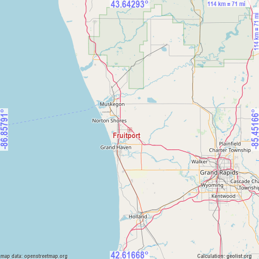
Fruitport GPS coordinates[2]
43° 7' 55.056" North, 86° 9' 17.208" West
| Map corner | latitude | longitude |
|---|---|---|
| Upper-left | 43.64293°, | -86.85791° |
| Center: | 43.13196°, | -86.15478° |
| Lower-right: | 42.61668°, | -85.45166° |
| Map W x H: | 114.1×114.1 km | = 70.9×70.9mi |
| max Lat: | 71.29058° ⇑15.7% North |
| Fruitport: | 43.13196° |
| min Lat: | ⇓84.3% South 19.06759° |
| min Long | Fruitport | max Long |
| -171.73463° | -86.15478° | -66.98998° |
| W 52.5%⇐ | ⇒47.5% E |
Elevation
Elevation of Fruitport is 192 m = 630 ft, and this is 102.8 m = 337 ft below average elevation for this country.
| Max E: |
3189 m = 10463 ft | 51.6% |
| Avg. | 294.8 m = 967 ft | |
| Fruitport | 192 m = 630 ft | |
Min E: |
-60 m = -197 ft | 48.4% |
See also: United States elevation on elevation.city.
Geographical zone
Fruitport is located in North temperate zone (between Tropic of Cancer and the Arctic Circle). Distance of this Northern Tropic circle is 2189.9 km =1360.7 mi to South.| Distance of | km | miles | from Fruitport |
|---|---|---|---|
| North Pole | 5211.2 | 3238.1 | to North |
| Arctic Circle | 2605.3 | 1618.9 | to North |
| Tropic Cancer | 2189.9 | 1360.7 | to South |
| Equator | 4795.8 | 2980 | to South |


Nearby cities:
15 places around Fruitport: (largest is in red/bold)
• Allendale
24.1 km =15 mi,  137°
137°
• Coopersville
19.4 km =12.1 mi,  112°
112°
• Ferrysburg
7.5 km =4.7 mi,  225°
225°
• Grand Haven
9.7 km =6 mi,  217°
217°
• Kent City
34.2 km =21.3 mi,  73°
73°
• Lakewood Club
27.9 km =17.3 mi,  342°
342°
• Muskegon
13.7 km =8.5 mi,  326°
326°
• Muskegon Heights
10.3 km =6.4 mi,  318°
318°
• North Muskegon
16.6 km =10.3 mi, 326°
• Norton Shores
9.8 km =6.1 mi,  294°
294°
• Ravenna
18.8 km =11.7 mi, 70°
• Roosevelt Park
11.9 km =7.4 mi,  306°
306°
• Spring Lake
7 km =4.3 mi,  209°
209°
• Twin Lake
25.7 km =16 mi,  358°
358°
• Wolf Lake
14.1 km =8.8 mi,  14°
14°
Sources, notices
• [Note1] Compared only with cities in United States existing in our database
• [Src1] Map data: © OpenStreetMap contributors (CC-BY-SA)
• [Src2] Other city data from geonames.org with taken over terms of usage.
• [Src3] Geographical zone / Annual Mean Temperature by Robert A. Rohde @ Wikipedia
