Grand Haven geodata
Grand Haven (Michigan) is a seat of a second-order administrative division; located in United States in America/Detroit (GMT-4) time zone. With population of 11,062 people, there are 4163 cities with bigger population in this country. Compared to other cities in United States, 83.7% of cities are located further ↓South; 52.3% of cities are located further ←West and 53.9% of cities have higher elevation than Grand Haven. Note1


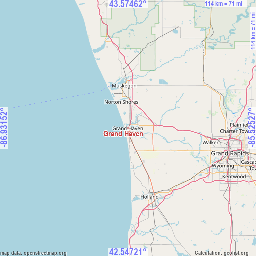
Grand Haven GPS coordinates[2]
43° 3' 47.052" North, 86° 13' 42.204" West
| Map corner | latitude | longitude |
|---|---|---|
| Upper-left | 43.57462°, | -86.93152° |
| Center: | 43.06307°, | -86.22839° |
| Lower-right: | 42.54721°, | -85.52527° |
| Map W x H: | 114.2×114.2 km | = 71×71mi |
| max Lat: | 71.29058° ⇑16.3% North |
| Grand Haven: | 43.06307° |
| min Lat: | ⇓83.7% South 19.06759° |
| min Long | Grand Haven | max Long |
| -171.73463° | -86.22839° | -66.98998° |
| W 52.3%⇐ | ⇒47.7% E |
Elevation
Elevation of Grand Haven is 184 m = 604 ft, and this is 110.8 m = 364 ft below average elevation for this country.
| Max E: |
3189 m = 10463 ft | 53.9% |
| Avg. | 294.8 m = 967 ft | |
| Grand Haven | 184 m = 604 ft | |
Min E: |
-60 m = -197 ft | 46.1% |
See also: United States elevation on elevation.city.
Geographical zone
Grand Haven is located in North temperate zone (between Tropic of Cancer and the Arctic Circle). Distance of this Northern Tropic circle is 2182.2 km =1356 mi to South.| Distance of | km | miles | from Grand Haven |
|---|---|---|---|
| North Pole | 5218.9 | 3242.9 | to North |
| Arctic Circle | 2613 | 1623.6 | to North |
| Tropic Cancer | 2182.2 | 1356 | to South |
| Equator | 4788.2 | 2975.2 | to South |


Nearby cities:
15 places around Grand Haven: (largest is in red/bold)
• Allendale
24.5 km =15.2 mi,  114°
114°
• Beechwood
30.7 km =19.1 mi,  164°
164°
• Coopersville
23.9 km =14.9 mi,  89°
89°
• Ferrysburg
2.5 km =1.6 mi,  15°
15°
• Fruitport
9.7 km =6 mi,  37°
37°
• Holland
32.1 km =19.9 mi, 162°
• Muskegon
19.1 km =11.9 mi,  355°
355°
• Muskegon Heights
15.4 km =9.6 mi, 356°
• North Muskegon
21.7 km =13.5 mi,  351°
351°
• Norton Shores
12.1 km =7.5 mi, 346°
• Ravenna
27.5 km =17.1 mi,  59°
59°
• Roosevelt Park
15.2 km =9.4 mi, 346°
• Spring Lake
3 km =1.9 mi, 58°
• Wolf Lake
23.4 km =14.5 mi, 24°
• Zeeland
32.7 km =20.3 mi,  148°
148°
Sources, notices
• [Note1] Compared only with cities in United States existing in our database
• [Src1] Map data: © OpenStreetMap contributors (CC-BY-SA)
• [Src2] Other city data from geonames.org with taken over terms of usage.
• [Src3] Geographical zone / Annual Mean Temperature by Robert A. Rohde @ Wikipedia
