Hopkins geodata
Hopkins (Michigan) is a populated place; located in United States in America/Detroit (GMT-4) time zone. With population of 608 people, there are 19608 cities with bigger population in this country. Compared to other cities in United States, 80.7% of cities are located further ↓South; 53.6% of cities are located further ←West and 55.4% of cities have lower elevation than Hopkins. Note1


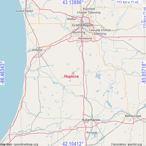
Hopkins GPS coordinates[2]
42° 37' 25.104" North, 85° 45' 37.08" West
| Map corner | latitude | longitude |
|---|---|---|
| Upper-left | 43.13886°, | -86.46343° |
| Center: | 42.62364°, | -85.7603° |
| Lower-right: | 42.10412°, | -85.05718° |
| Map W x H: | 115.1×115.1 km | = 71.5×71.5mi |
| max Lat: | 71.29058° ⇑19.3% North |
| Hopkins: | 42.62364° |
| min Lat: | ⇓80.7% South 19.06759° |
| min Long | Hopkins | max Long |
| -171.73463° | -85.7603° | -66.98998° |
| W 53.6%⇐ | ⇒46.4% E |
Elevation
Elevation of Hopkins is 220 m = 722 ft, and this is 74.8 m = 245 ft below average elevation for this country.
| Max E: |
3189 m = 10463 ft | 44.6% |
| Avg. | 294.8 m = 967 ft | |
| Hopkins | 220 m = 722 ft | |
Min E: |
-60 m = -197 ft | 55.4% |
See also: United States elevation on elevation.city.
Geographical zone
Hopkins is located in North temperate zone (between Tropic of Cancer and the Arctic Circle). Distance of this Northern Tropic circle is 2133.4 km =1325.6 mi to South.| Distance of | km | miles | from Hopkins |
|---|---|---|---|
| North Pole | 5267.8 | 3273.3 | to North |
| Arctic Circle | 2661.9 | 1654 | to North |
| Tropic Cancer | 2133.4 | 1325.6 | to South |
| Equator | 4739.3 | 2944.9 | to South |


Nearby cities:
15 places around Hopkins: (largest is in red/bold)
• Allegan
13.1 km =8.1 mi,  216°
216°
• Byron Center
21.2 km =13.2 mi,  8°
8°
• Caledonia
27.1 km =16.8 mi,  47°
47°
• Cutlerville
25.4 km =15.8 mi,  18°
18°
• Fennville
28.1 km =17.5 mi,  263°
263°
• Gobles
30.8 km =19.1 mi,  198°
198°
• Hudsonville
28.8 km =17.9 mi,  342°
342°
• Jenison
31.6 km =19.6 mi,  355°
355°
• Kentwood
28.9 km =18 mi, 19°
• Middleville
26.3 km =16.3 mi,  67°
67°
• Otsego
18.9 km =11.7 mi,  163°
163°
• Plainwell
22.4 km =13.9 mi, 155°
• Stony Point
30.7 km =19.1 mi,  117°
117°
• Wayland
11 km =6.8 mi,  59°
59°
• Zeeland
29.8 km =18.5 mi,  314°
314°
Sources, notices
• [Note1] Compared only with cities in United States existing in our database
• [Src1] Map data: © OpenStreetMap contributors (CC-BY-SA)
• [Src2] Other city data from geonames.org with taken over terms of usage.
• [Src3] Geographical zone / Annual Mean Temperature by Robert A. Rohde @ Wikipedia
