Fennville geodata
Fennville (Michigan) is a populated place; located in United States in America/Detroit (GMT-4) time zone. With population of 1,400 people, there are 14111 cities with bigger population in this country. Compared to other cities in United States, 80.5% of cities are located further ↓South; 52.7% of cities are located further ←West and 51.7% of cities have lower elevation than Fennville. Note1


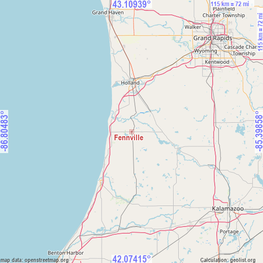
Fennville GPS coordinates[2]
42° 35' 38.112" North, 86° 6' 6.12" West
| Map corner | latitude | longitude |
|---|---|---|
| Upper-left | 43.10939°, | -86.80483° |
| Center: | 42.59392°, | -86.1017° |
| Lower-right: | 42.07415°, | -85.39858° |
| Map W x H: | 115.1×115.1 km | = 71.5×71.5mi |
| max Lat: | 71.29058° ⇑19.5% North |
| Fennville: | 42.59392° |
| min Lat: | ⇓80.5% South 19.06759° |
| min Long | Fennville | max Long |
| -171.73463° | -86.1017° | -66.98998° |
| W 52.7%⇐ | ⇒47.3% E |
Elevation
Elevation of Fennville is 205 m = 673 ft, and this is 89.8 m = 295 ft below average elevation for this country.
| Max E: |
3189 m = 10463 ft | 48.3% |
| Avg. | 294.8 m = 967 ft | |
| Fennville | 205 m = 673 ft | |
Min E: |
-60 m = -197 ft | 51.7% |
See also: United States elevation on elevation.city.
Geographical zone
Fennville is located in North temperate zone (between Tropic of Cancer and the Arctic Circle). Distance of this Northern Tropic circle is 2130.1 km =1323.6 mi to South.| Distance of | km | miles | from Fennville |
|---|---|---|---|
| North Pole | 5271.1 | 3275.3 | to North |
| Arctic Circle | 2665.2 | 1656.1 | to North |
| Tropic Cancer | 2130.1 | 1323.6 | to South |
| Equator | 4736 | 2942.8 | to South |


Nearby cities:
15 places around Fennville: (largest is in red/bold)
• Allegan
21.4 km =13.3 mi,  109°
109°
• Bangor
31.3 km =19.4 mi,  181°
181°
• Beechwood
22.7 km =14.1 mi,  354°
354°
• Byron Center
39.3 km =24.4 mi,  51°
51°
• Douglas
9.8 km =6.1 mi,  304°
304°
• Gobles
31.7 km =19.7 mi,  144°
144°
• Holland
21.5 km =13.4 mi,  358°
358°
• Hopkins
28.1 km =17.5 mi,  83°
83°
• Hudsonville
36.4 km =22.6 mi,  32°
32°
• Otsego
36.4 km =22.6 mi, 114°
• Plainwell
40.9 km =25.4 mi, 114°
• Saugatuck
10.7 km =6.6 mi,  309°
309°
• South Haven
25.5 km =15.8 mi,  213°
213°
• Wayland
38.4 km =23.9 mi, 76°
• Zeeland
25.2 km =15.7 mi,  15°
15°
Sources, notices
• [Note1] Compared only with cities in United States existing in our database
• [Src1] Map data: © OpenStreetMap contributors (CC-BY-SA)
• [Src2] Other city data from geonames.org with taken over terms of usage.
• [Src3] Geographical zone / Annual Mean Temperature by Robert A. Rohde @ Wikipedia
