Vicksburg geodata
Vicksburg (Michigan) is a populated place; located in United States in America/Detroit (GMT-4) time zone. With population of 3,230 people, there are 9261 cities with bigger population in this country. Compared to other cities in United States, 76.7% of cities are located further ↓South; 54.5% of cities are located further ←West and 65% of cities have lower elevation than Vicksburg. Note1
Administrative division(s):
- Level 1: Michigan
- Level 2: Kalamazoo County
- Level 3: Township of Schoolcraft


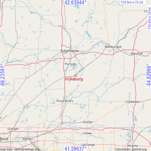
Vicksburg GPS coordinates[2]
42° 7' 12.18" North, 85° 31' 58.008" West
| Map corner | latitude | longitude |
|---|---|---|
| Upper-left | 42.63944°, | -86.23591° |
| Center: | 42.12005°, | -85.53278° |
| Lower-right: | 41.59637°, | -84.82966° |
| Map W x H: | 116×116 km | = 72.1×72.1mi |
| max Lat: | 71.29058° ⇑23.3% North |
| Vicksburg: | 42.12005° |
| min Lat: | ⇓76.7% South 19.06759° |
| min Long | Vicksburg | max Long |
| -171.73463° | -85.53278° | -66.98998° |
| W 54.5%⇐ | ⇒45.5% E |
Elevation
Elevation of Vicksburg is 262 m = 860 ft, and this is 32.8 m = 108 ft below average elevation for this country.
| Max E: |
3189 m = 10463 ft | 35% |
| Avg. | 294.8 m = 967 ft | |
| Vicksburg | 262 m = 860 ft | |
Min E: |
-60 m = -197 ft | 65% |
See also: United States elevation on elevation.city.
Geographical zone
Vicksburg is located in North temperate zone (between Tropic of Cancer and the Arctic Circle). Distance of this Northern Tropic circle is 2077.4 km =1290.8 mi to South.| Distance of | km | miles | from Vicksburg |
|---|---|---|---|
| North Pole | 5323.8 | 3308.1 | to North |
| Arctic Circle | 2717.9 | 1688.8 | to North |
| Tropic Cancer | 2077.4 | 1290.8 | to South |
| Equator | 4683.3 | 2910.1 | to South |


Nearby cities:
15 places around Vicksburg: (largest is in red/bold)
• Athens
24.8 km =15.4 mi,  98°
98°
• Centreville
21.9 km =13.6 mi,  179°
179°
• Climax
20.9 km =13 mi,  51°
51°
• Colon
24.9 km =15.5 mi,  136°
136°
• Comstock Northwest
22.5 km =14 mi,  3°
3°
• Eastwood
20.4 km =12.7 mi,  355°
355°
• Galesburg
21 km =13 mi,  26°
26°
• Kalamazoo
19.6 km =12.2 mi,  346°
346°
• Mattawan
23 km =14.3 mi,  295°
295°
• Mendon
14.4 km =8.9 mi,  151°
151°
• Parchment
23.3 km =14.5 mi, 352°
• Portage
9.8 km =6.1 mi,  336°
336°
• Schoolcraft
8.7 km =5.4 mi,  265°
265°
• Three Rivers
21.2 km =13.2 mi,  202°
202°
• Westwood
22 km =13.7 mi, 337°
Sources, notices
• [Note1] Compared only with cities in United States existing in our database
• [Src1] Map data: © OpenStreetMap contributors (CC-BY-SA)
• [Src2] Other city data from geonames.org with taken over terms of usage.
• [Src3] Geographical zone / Annual Mean Temperature by Robert A. Rohde @ Wikipedia
