Owosso geodata
Owosso (Michigan) is a populated place; located in United States in America/Detroit (GMT-4) time zone. With population of 14,699 people, there are 3296 cities with bigger population in this country. Compared to other cities in United States, 83.3% of cities are located further ↓South; 58.7% of cities are located further ←West and 56.1% of cities have lower elevation than Owosso. Note1


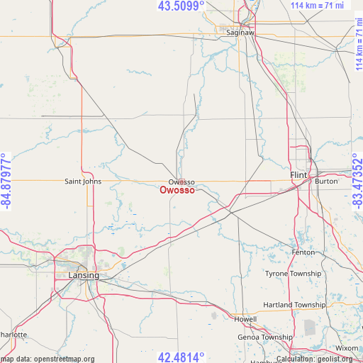
Owosso GPS coordinates[2]
42° 59' 52.08" North, 84° 10' 35.904" West
| Map corner | latitude | longitude |
|---|---|---|
| Upper-left | 43.5099°, | -84.87977° |
| Center: | 42.9978°, | -84.17664° |
| Lower-right: | 42.4814°, | -83.47352° |
| Map W x H: | 114.4×114.4 km | = 71.1×71.1mi |
| max Lat: | 71.29058° ⇑16.7% North |
| Owosso: | 42.9978° |
| min Lat: | ⇓83.3% South 19.06759° |
| min Long | Owosso | max Long |
| -171.73463° | -84.17664° | -66.98998° |
| W 58.7%⇐ | ⇒41.3% E |
Elevation
Elevation of Owosso is 223 m = 732 ft, and this is 71.8 m = 236 ft below average elevation for this country.
| Max E: |
3189 m = 10463 ft | 43.9% |
| Avg. | 294.8 m = 967 ft | |
| Owosso | 223 m = 732 ft | |
Min E: |
-60 m = -197 ft | 56.1% |
See also: United States elevation on elevation.city.
Geographical zone
Owosso is located in North temperate zone (between Tropic of Cancer and the Arctic Circle). Distance of this Northern Tropic circle is 2175 km =1351.5 mi to South.| Distance of | km | miles | from Owosso |
|---|---|---|---|
| North Pole | 5226.2 | 3247.4 | to North |
| Arctic Circle | 2620.3 | 1628.2 | to North |
| Tropic Cancer | 2175 | 1351.5 | to South |
| Equator | 4780.9 | 2970.7 | to South |


Nearby cities:
15 places around Owosso: (largest is in red/bold)
• Bancroft
16.1 km =10 mi,  145°
145°
• Byron
27.1 km =16.8 mi,  135°
135°
• Chesaning
21.4 km =13.3 mi,  13°
13°
• Corunna
5.1 km =3.2 mi,  110°
110°
• Durand
18.3 km =11.4 mi,  121°
121°
• Elsie
19.9 km =12.4 mi,  300°
300°
• Laingsburg
18.6 km =11.6 mi,  229°
229°
• Lennon
20.1 km =12.5 mi,  94°
94°
• Middletown
2.9 km =1.8 mi, 117°
• Morrice
17.7 km =11 mi,  180°
180°
• New Haven
10.8 km =6.7 mi, 10°
• New Lothrop
21.4 km =13.3 mi,  51°
51°
• Ovid
15.9 km =9.9 mi,  273°
273°
• Perry
19.4 km =12.1 mi,  190°
190°
• Vernon
13.6 km =8.5 mi, 118°
Sources, notices
• [Note1] Compared only with cities in United States existing in our database
• [Src1] Map data: © OpenStreetMap contributors (CC-BY-SA)
• [Src2] Other city data from geonames.org with taken over terms of usage.
• [Src3] Geographical zone / Annual Mean Temperature by Robert A. Rohde @ Wikipedia
