Elsie geodata
Elsie (Michigan) is a populated place; located in United States in America/Detroit (GMT-4) time zone. With population of 971 people, there are 16484 cities with bigger population in this country. Compared to other cities in United States, 84% of cities are located further ↓South; 57.8% of cities are located further ←West and 56.4% of cities have lower elevation than Elsie. Note1


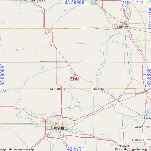
Elsie GPS coordinates[2]
43° 5' 19.104" North, 84° 23' 12.948" West
| Map corner | latitude | longitude |
|---|---|---|
| Upper-left | 43.59998°, | -85.09006° |
| Center: | 43.08864°, | -84.38693° |
| Lower-right: | 42.573°, | -83.68381° |
| Map W x H: | 114.2×114.2 km | = 71×71mi |
| max Lat: | 71.29058° ⇑16% North |
| Elsie: | 43.08864° |
| min Lat: | ⇓84% South 19.06759° |
| min Long | Elsie | max Long |
| -171.73463° | -84.38693° | -66.98998° |
| W 57.8%⇐ | ⇒42.2% E |
Elevation
Elevation of Elsie is 224 m = 735 ft, and this is 70.8 m = 232 ft below average elevation for this country.
| Max E: |
3189 m = 10463 ft | 43.6% |
| Avg. | 294.8 m = 967 ft | |
| Elsie | 224 m = 735 ft | |
Min E: |
-60 m = -197 ft | 56.4% |
See also: United States elevation on elevation.city.
Geographical zone
Elsie is located in North temperate zone (between Tropic of Cancer and the Arctic Circle). Distance of this Northern Tropic circle is 2185.1 km =1357.8 mi to South.| Distance of | km | miles | from Elsie |
|---|---|---|---|
| North Pole | 5216.1 | 3241.1 | to North |
| Arctic Circle | 2610.2 | 1621.9 | to North |
| Tropic Cancer | 2185.1 | 1357.8 | to South |
| Equator | 4791 | 2977 | to South |


Nearby cities:
15 places around Elsie: (largest is in red/bold)
• Ashley
13 km =8.1 mi,  326°
326°
• Bath
30.4 km =18.9 mi,  189°
189°
• Chesaning
24.5 km =15.2 mi,  64°
64°
• Corunna
24.9 km =15.5 mi,  118°
118°
• DeWitt
31.1 km =19.3 mi,  208°
208°
• Fowler
30.3 km =18.8 mi,  251°
251°
• Ithaca
28.8 km =17.9 mi,  321°
321°
• Laingsburg
22.2 km =13.8 mi,  172°
172°
• Maple Rapids
24.8 km =15.4 mi,  274°
274°
• Middletown
22.7 km =14.1 mi, 120°
• New Haven
19 km =11.8 mi,  88°
88°
• Ovid
9.3 km =5.8 mi, 172°
• Owosso
19.9 km =12.4 mi, 120°
• Saint Charles
30.6 km =19 mi,  40°
40°
• Saint Johns
17 km =10.6 mi,  235°
235°
Sources, notices
• [Note1] Compared only with cities in United States existing in our database
• [Src1] Map data: © OpenStreetMap contributors (CC-BY-SA)
• [Src2] Other city data from geonames.org with taken over terms of usage.
• [Src3] Geographical zone / Annual Mean Temperature by Robert A. Rohde @ Wikipedia
