Chesaning geodata
Chesaning (Michigan) is a populated place; located in United States in America/Detroit (GMT-4) time zone. With population of 2,288 people, there are 11112 cities with bigger population in this country. Compared to other cities in United States, 84.7% of cities are located further ↓South; 59% of cities are located further ←West and 51.4% of cities have higher elevation than Chesaning. Note1
Administrative division(s):
- Level 1: Michigan
- Level 2: Saginaw County
- Level 3: Township of Chesaning


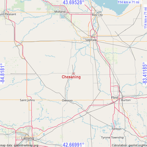
Chesaning GPS coordinates[2]
43° 11' 5.1" North, 84° 6' 53.892" West
| Map corner | latitude | longitude |
|---|---|---|
| Upper-left | 43.69528°, | -84.8181° |
| Center: | 43.18475°, | -84.11497° |
| Lower-right: | 42.66991°, | -83.41185° |
| Map W x H: | 114×114 km | = 70.8×70.8mi |
| max Lat: | 71.29058° ⇑15.3% North |
| Chesaning: | 43.18475° |
| min Lat: | ⇓84.7% South 19.06759° |
| min Long | Chesaning | max Long |
| -171.73463° | -84.11497° | -66.98998° |
| W 59%⇐ | ⇒41% E |
Elevation
Elevation of Chesaning is 193 m = 633 ft, and this is 101.8 m = 334 ft below average elevation for this country.
| Max E: |
3189 m = 10463 ft | 51.4% |
| Avg. | 294.8 m = 967 ft | |
| Chesaning | 193 m = 633 ft | |
Min E: |
-60 m = -197 ft | 48.6% |
See also: United States elevation on elevation.city.
Geographical zone
Chesaning is located in North temperate zone (between Tropic of Cancer and the Arctic Circle). Distance of this Northern Tropic circle is 2195.8 km =1364.4 mi to South.| Distance of | km | miles | from Chesaning |
|---|---|---|---|
| North Pole | 5205.4 | 3234.5 | to North |
| Arctic Circle | 2599.5 | 1615.3 | to North |
| Tropic Cancer | 2195.8 | 1364.4 | to South |
| Equator | 4801.7 | 2983.6 | to South |


Nearby cities:
15 places around Chesaning: (largest is in red/bold)
• Birch Run
27 km =16.8 mi,  74°
74°
• Bridgeport
27.1 km =16.8 mi,  44°
44°
• Burt
17.9 km =11.1 mi, 71°
• Corunna
22.5 km =14 mi,  180°
180°
• Elsie
24.5 km =15.2 mi,  244°
244°
• Flushing
25.3 km =15.7 mi,  122°
122°
• Hemlock
27.2 km =16.9 mi,  339°
339°
• Lennon
26.9 km =16.7 mi,  146°
146°
• Middletown
22.2 km =13.8 mi,  186°
186°
• Montrose
18 km =11.2 mi,  92°
92°
• New Haven
10.6 km =6.6 mi,  197°
197°
• New Lothrop
14 km =8.7 mi, 122°
• Owosso
21.4 km =13.3 mi, 193°
• Saint Charles
12.6 km =7.8 mi,  350°
350°
• Shields
26.1 km =16.2 mi,  10°
10°
Sources, notices
• [Note1] Compared only with cities in United States existing in our database
• [Src1] Map data: © OpenStreetMap contributors (CC-BY-SA)
• [Src2] Other city data from geonames.org with taken over terms of usage.
• [Src3] Geographical zone / Annual Mean Temperature by Robert A. Rohde @ Wikipedia
