Pontiac geodata
Pontiac (Michigan) is a seat of a second-order administrative division; located in United States in America/Detroit (GMT-4) time zone. With population of 59,917 people, there are 749 cities with bigger population in this country. Compared to other cities in United States, 80.9% of cities are located further ↓South; 61.2% of cities are located further ←West and 70.6% of cities have lower elevation than Pontiac. Note1


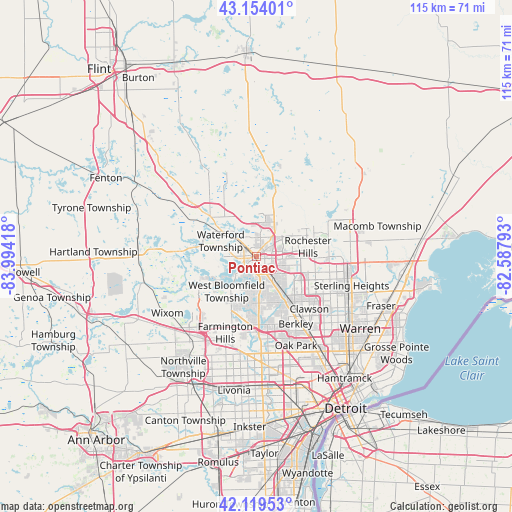
Pontiac GPS coordinates[2]
42° 38' 20.112" North, 83° 17' 27.78" West
| Map corner | latitude | longitude |
|---|---|---|
| Upper-left | 43.15401°, | -83.99418° |
| Center: | 42.63892°, | -83.29105° |
| Lower-right: | 42.11953°, | -82.58793° |
| Map W x H: | 115×115 km | = 71.5×71.5mi |
| max Lat: | 71.29058° ⇑19.1% North |
| Pontiac: | 42.63892° |
| min Lat: | ⇓80.9% South 19.06759° |
| min Long | Pontiac | max Long |
| -171.73463° | -83.29105° | -66.98998° |
| W 61.2%⇐ | ⇒38.8% E |
Elevation
Elevation of Pontiac is 289 m = 948 ft, and this is 5.8 m = 19 ft below average elevation for this country.
| Max E: |
3189 m = 10463 ft | 29.4% |
| Avg. | 294.8 m = 967 ft | |
| Pontiac | 289 m = 948 ft | |
Min E: |
-60 m = -197 ft | 70.6% |
See also: Pontiac elevation on elevation.city.
Geographical zone
Pontiac is located in North temperate zone (between Tropic of Cancer and the Arctic Circle). Distance of this Northern Tropic circle is 2135.1 km =1326.7 mi to South.| Distance of | km | miles | from Pontiac |
|---|---|---|---|
| North Pole | 5266.1 | 3272.2 | to North |
| Arctic Circle | 2660.2 | 1653 | to North |
| Tropic Cancer | 2135.1 | 1326.7 | to South |
| Equator | 4741 | 2945.9 | to South |


Nearby cities:
15 places around Pontiac: (largest is in red/bold)
• Auburn Hills
7.1 km =4.4 mi,  40°
40°
• Beverly Hills
13.9 km =8.6 mi,  156°
156°
• Bingham Farms
13.8 km =8.6 mi,  173°
173°
• Birmingham
12.2 km =7.6 mi,  147°
147°
• Bloomfield Hills
7.2 km =4.5 mi, 148°
• Clarkston
15 km =9.3 mi,  315°
315°
• Franklin
13 km =8.1 mi,  185°
185°
• Keego Harbor
5.5 km =3.4 mi,  231°
231°
• Orchard Lake
8.4 km =5.2 mi,  222°
222°
• Rochester
13.7 km =8.5 mi,  70°
70°
• Rochester Hills
11.7 km =7.3 mi,  79°
79°
• Sylvan Lake
4.3 km =2.7 mi, 225°
• Troy
12.1 km =7.5 mi,  107°
107°
• Waterford
11.6 km =7.2 mi,  301°
301°
• West Bloomfield Township
10.9 km =6.8 mi, 224°
Sources, notices
• [Note1] Compared only with cities in United States existing in our database
• [Src1] Map data: © OpenStreetMap contributors (CC-BY-SA)
• [Src2] Other city data from geonames.org with taken over terms of usage.
• [Src3] Geographical zone / Annual Mean Temperature by Robert A. Rohde @ Wikipedia
